~ |
Online free nautical charts and publications
open data/open access - libre accès
Cartes marines gratuites et ouvrages nautiques en ligne
 | INT |

| Document | 
| ||
Private companies/ Sociétés privées
About Nautical Free
Nautical Free provides a list of free nautical charts and online publications.There is a list by country from letter A to letter V, for each country the organizations and for each organization a list of free online documents (charts, nautical books, notice to mariners...). There is two special lists: one for the international organizations and one for the private companies. There is also a reverse list by type of documents: sailing directions, radio signals, tide tables, nautical charts... You can also find on Nautical Free wave forecast maps for tomorrow, space weather forecast for GPS, how to check your computer clock, as well as information about celestial navigation or about ice navigation...
Au sujet de Nautical Free
Nautical Free fournit une liste de cartes marines gratuites et d'ouvrages nautiques en ligne.Il y a une liste par pays de la lettre A à la lettre V, pour chaque pays les organisations et pour chaque organisation une liste de documents libres en ligne (cartes marines, ouvrages nautiques, avis aux navigateurs...). Il existe deux listes spéciales : une pour les organisations internationales et une pour les sociétés privées. Il existe également une liste inverse par type de documents : instructions nautiques, ouvrages de radiosignaux, tables des marées, cartes marines... Vous trouverez également sur Nautical Free des cartes de prévision de la hauteur des vagues pour demain, des prévisions de la météo de l'espace pour les GPS, comment vérifier l'heure de son ordinateur, ainsi que des informations sur la navigation astronomique ou la navigation dans les glaces...
Advice / Conseils
For navigation use only updated regulatory documents /
Pour la navigation n'utiliser que des documents réglementaires à jour.
GPS is more accurate than nautical charts /
Un GPS est plus précis qu'un carte marine
Web Servers / Serveurs Web
You can use the nearest or faster server / Vous pouvez utiliser le serveur le plus proche ou le plus rapide :
- French mirror with one page by section / Serveur en France avec une page par section : http://nauticalfree.free.fr
- French mirror on one page / Serveur en France sur une page : http://nauticalfree.free.fr/onepage.html
- French mirror without image on one page / Serveur en France sans image sur une page : http://nauticalfree.free.fr/noimage/
- US mirror with one page by section / Serveur au États-Unis avec une page par section : http://nauticalfree.eu5.org
- US mirror on one page / Serveur au États-Unis sur une page : http://nauticalfree.eu5.org/onepage.html
- US mirror without image on one page / Serveur au États-Unis sans image sur une page : http://nauticalfree.eu5.org/noimage/
- US mirror on seven pages / Serveur au États-Unis sur sept pages : https://sites.google.com/site/nauticalfree/
Caption / Légende
- The nautical books are in standard fonts / Les ouvrages sont en caractères droits
- In Italic the maps and the charts / Les cartes sont en italiques
- The last item for an organization is the Notices to Mariners. The first issue of each year is often a special publication /
La dernier item pour un service hydrographique est un lien vers les avis au navigateurs. Le premier numéro de chaque année est souvent un numéro spécial
- Raster Navigational Charts (RNC)
- Bitmap electronic images of paper charts that conform to IHO standard S-61 /
Carte marine matricielle, fac-similé numérique d'une carte papier (scan) conforme à la norme de l'OHI S-61 - Electronic Navigational Charts (ENC)
- Vector charts that conform to IHO standard S-57 /
Carte électronique de navigation, carte vectorielle conforme à la norme de l'OHI S-57
|
|
Cartes marines gratuites et ouvrages nautiques en ligne : Sociétés privées
Private companies / Sociétés privées
- Aqua Map: Online charts
- C-MAP: Online Charts
- FlyToMap: Online Charts
- Imray: Corrections to Charts and Books
- Inmarsat: Maritime Satellite Handbooks
- Iridium: Maritime Satellite Ressources
- Navionics: Online Charts
- NV Charts: Online charts
- OpenSeaMap: The free nautical chart
- Portmaps: Online charts
Aqua Map (by GEC)
- Aqua Viewer Editing
View online charts / Cartes consultables en ligne
Not for navigational use / Ne pas utilisez pour la navigation
This tool is for all those would display, modify and create at a mouse click, without any installation, a GPS Route, Track or Marker and share them with friends. Coverage is relative to USA, Canada, Brazil, Australia, New Zealand, Norway, France and Italy.Aqua Map: US coasts, Florida, Miami Aqua Map: US coasts, Florida, Miami

- Aqua Viewer Editing
C-MAP
- Chart Explorer
View online ENC charts / Carte ENC consultable en ligne
Not for navigational use / Ne pas utilisez pour la navigation
Worlwide coverage with C-MAP.
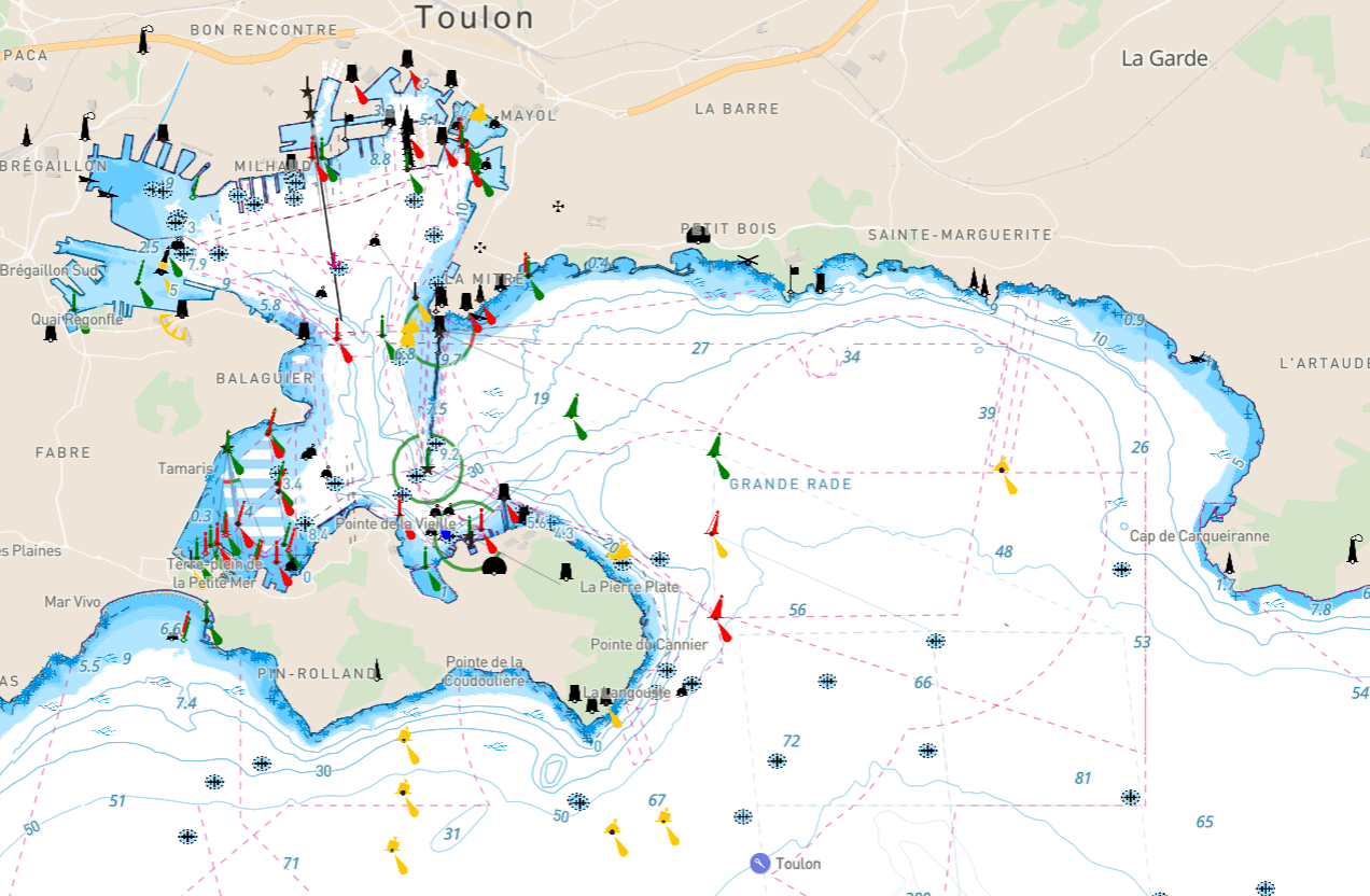
- Marine map viewer
View online ENC charts / Carte ENC consultable en ligne
Not for navigational use / Ne pas utilisez pour la navigation
Worlwide coverage with C-MAP and OSM.

- Chart Explorer
FlyToMap
- Marine map web viewer
View online charts / Cartes consultables en ligne
Not for navigational use / Ne pas utilisez pour la navigation
This product is a complete Marine Chart based on the most detailed and up to date paper Nautical charts and Electronic Nautical Charts (ENC) available. Full coverage of US, Europe (partial), and New Zealand marine areas. All WaterMaps are including Coastline, Depth Contours, Spot Soundings, Fishing Areas, Restriction Areas, Bottom Obstructions, Rocks, Wrecks, Lights, Buoys, Beacons, etc. There is ENC with the option FLYTOMAP and raster charts with the option RASTER on the top right. - Marine map iOS viewer
View online charts for iOS devices / Cartes consultables en ligne pour iOS
Not for navigational use / Ne pas utilisez pour la navigation
Flytomap has done a free app on iOS devices with a world wide chart coverage: Marine GPS FlyToMap HD.

- Marine map web viewer
Imray charts, books and digital
- Charts and Books Catalogue
Imray charts, pilot books, inland waterway guides and maps almanacs and other nautical books. Imray chart coverage is divided into several series: Northwest Europe, Mediterranean, Atlantic and Eastern Caribbean (PDF file).
- Imray charts: Paper charts - Digital charts
- Imray Books
- Imray digital products
- Chart Finder
Use Chart Finder to select charts from Imray, Admiralty, SHOM and Kartverket on a map. Charts are categorised by chart publisher, scale and usage. The display of chart categories can be toggled on/off using the selection filters.
- Key to symbols and abbreviations used on Imray Charts
Symbols and abbreviations: IALA buoyage system region A, small craft symbols, seabed characteristics, abbreviations.
- Explore with Imray
Explore with Imray offers the content from Imray’s world-renowned library of pilot books in a new digital, geolocated format. With a free account you will be able to access 10 pin locations of your choice before you are asked to join to access further data.
- Chartlets of East Coast rivers
Every spring, we publish chartlets of East Coast rivers (Suffolk, UK) based on Trinity House surveys: Woodbridge Haven (River Deben entrance) and Orford Haven (River Ore entrance). Not to be used for navigation.
- Support & FAQs
Explore with Imray - Imray Navigator tutorial videos - Imray Navigator FAQs - Tides Planner tutorial videos - Tides Planner FAQs
s
- Almanac Corrections
Corrections to the Cruising Almanac are published monthly to take into account Notices to Mariners, changes to buoyage and lights and other new developments which have taken place since the Almanac cut off date which is usually in mid-May. The latest corrections may be downloaded from this web site, and the inclusion of these corrections for the appropriate year makes your Cruising Almanac correct to the given cut off date.
- Imray corrections & supplements
Keeping Imray charts and books up to date. You can keep your charts up to date by downloading Imray Correction Notices. With a Printing History - a list of all chart edition and printing dates and the Norie's Bulletin of Corrections - a non-cumulative list of corrections for all Imray charts published each quarter. Imray pilot books are updated and corrected at frequent intervals via downloadble supplements.
- Charts and Books Catalogue
Inmarsat - Mobile satellite communications
- Inmarsat Maritime Communications Handbook
The handbook has been produced to help users of the Inmarsat network understand how the Inmarsat system operates. Contents: Inmarsat and its network of satellites - Inmarsat's role within the GMDSS - Accounting, billing and settlement process - Inmarsat-C system and Maritime Safety Information (MSI) - Inmarsat's data services (Issue 4, edition 2002).
- The Evolution of Safety at Sea
Short presentation of Inmarsat safety services.
- International SafetyNET Handbook

This handbook is intended for mariners, to explain the operation of the International SafetyNET service as an element of the IMO Global Maritime Distress and Safety System (GMDSS). SafetyNET is the service for broadcasting and automatic reception of Maritime Safety Information (MSI) via Enhanced Group Call (EGC) system. This handbook deals mainly with the distribution of Maritime Safety Information (MSI) via satellite using the International SafetyNET services. This handbook also explains how mariners can use SafetyNET services to obtain vital MSI tailored to the needs of the vessel. - Inmarsat SafetyNET II User Guide
This document describes the SafetyNET II system, which is part of the Inmarsat Maritime Safety Services offering. This User Guide is intended for Maritime Safety Information Providers (MSIPs) and provides a high-level description of the features available and instructions on how to use the system.
- SAFETYNET - Satellite transmission schedule for GMDSS service
EGC MSI Broadcast Systems Operational Information. This is the latest information about the transmission schedule (UTC) for NAVAREA with navigational information and METAREA with meteorological information. Broadcast times for MET information published in the table above are for routine Weather Messages. Storm Warnings are also broadcast on receipt. Routine broadcasts of Navigational Warnings and meteorological forecasts are made at scheduled times over a single nominated satellite for each NAVAREA/METAREA. Unscheduled broadcasts of SAR alert relays and severe weather warnings will be made over all satellites which serve the area concerned (UKHO NtM, Section VI).
- NAVAREA - Navigational information (page 180, 6.10)
- METAREA - Meteorological information (pages 181 & 182, 6.11 & 6.12)
- Inmarsat RescueNET Handbook
This document describes the RescueNET system, which is part of the Inmarsat Maritime Safety Services offering. This Handbook is intended for Rescue Co-ordination Centres (RCCs) and provides a high-level description of the features available. The RescueNET service links across Inmarsat C, Mini C, and Inmarsat Fleet Safety for EGC broadcast service, as well as enable RCCs to communicate directly with Inmarsat Fleet Safety Ship Earth Stations (SES) for Distress Alert and direct SAR coordination.
- Safety communications using Inmarsat C
Distress alerts and distress priority messages transmitted via the Inmarsat C system are routed through a land earth station to a Maritime Rescue Co-ordination Centre (MRCC). Inmarsat C terminals can also receive broadcast messages from SafetyNET the international service for the broadcast and automatic reception of maritime safety information (MSI) and search and rescue (SAR) related information. Also satellite coverage for Inmarsat C.
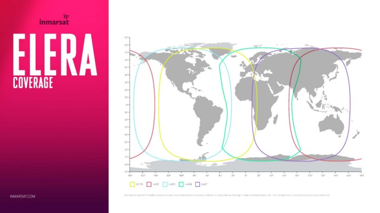
- Inmarsat satellite coverage
Coverage maps for L-band satellites and K-band satellites.
- Inmarsat Free Emergency Calls
How you can get free Emergency Calls with Inmarsat. Free Emergency call codes with Fleet Xpress and FleetBroadband.
- Inmarsat Design & Installation Guidelines (DIGS)
The “Design and Installation Guidelines” provide general information on the design and installation of Inmarsat equipment operating within the Global Maritime Distress and Safety System (GMDSS).
- How calls are routed through our network
Phone calls and data connections are routed by the international telecoms carriers based on the numbering formats described here. Calls from the terrestrial telephone network (PSTN) to an Inmarsat network are made using the Inmarsat +870 international dialling code.
- FleetBroadband & Fleet One Firmware
Find the latest firmware for your FleetBroadband terminal here. Where available, the downloads include application notes and installation guidance.
- Ships Directory
Ships Directory: Calling shore to ship. Find contact numbers for vessels fitted with Inmarsat. Type at least three characters of the ship's name.
- Maritime Rescue Co-ordination Centres (MRCCs)
Distress alerts, calls and distress priority messages transmitted over the Inmarsat network are routed via its Land Earth Stations (LESs) or Shore Access Stations (SASs) to shore-based Maritime Rescue Co-ordination Centres (MRCCs) around the world.

- Inmarsat Maritime Communications Handbook
Iridium - Global satellite communications
- Iridium GMDSS
Iridium GMDSS enhances your safety at sea, offering reliable coverage where no other options exist. Our unique constellation of 66 cross-linked satellites in Low-Earth Orbit provides reliable coverage, even in adverse weather, around the entire globe, including over the Arctic and Antarctic waters in Sea Area A4.
- Iridium GMDSS Service Updates
Iridium GMDSS enhances safety at sea, offering reliable coverage where no other options exist. Scroll below for the latest details on various product and service approvals from regulatory bodies around the world. With NAVAREAs/METAREAs sending information to Iridium SafetyCast. Content: Rescue Coordination Centers (RCC), GMDSS Equipment Type Approvals, Safetycast MSI Broadcast, METAREAS & NAVAREAS sending information to Iridium SafetyCast.
- SAFETYNET - Satellite transmission schedule for GMDSS service
EGC MSI Broadcast Systems Operational Information. This is the latest information about the transmission schedule (UTC) for NAVAREA with navigational information and METAREA with meteorological information. Broadcast times for MET information published in the table above are for routine Weather Messages. Storm Warnings are also broadcast on receipt. Routine broadcasts of Navigational Warnings and meteorological forecasts are made at scheduled times over a single nominated satellite for each NAVAREA/METAREA. Unscheduled broadcasts of SAR alert relays and severe weather warnings will be made over all satellites which serve the area concerned (UKHO NtM, Section VI).
- NAVAREA - Navigational information (page 180, 6.10)
- METAREA - Meteorological information (pages 181 & 182, 6.11 & 6.12)
- NAVAREA I & METAREA I - Notification of full operational capability of Iridium safetycast services
Effective from 19 dec 2022 the NAVAREA I and METAREA I co-ordinators will have full operational capability (FPC) for broadcasting navigational and meteorological warnings via the Iridium safetycast service. The Co-Ordinators will promulgate SafetyCast messages as part of a numbered series in accordance with the joint IMO/IHO/WMO maritime safety information manual (NtM 02/2023, Section VI, page 56, 6.1).
- Iridium GMDSS recognised mobile satellite service
This note is intended to give awareness and advise UK flag vessels of a new recognised mobile satellite service in the Global Maritime Distress and Safety System (GMDSS). The IMO has recognised Iridium as meeting the necessary technical criteria of a GMDSS Satellite Service (UK MCA, MIN 636, 2021).
- Iridium GMDSS Frequently Asked Questions
Iridium GMDSS FAQ: General Questions, Iridium GMDSS Services, Iridium GMDSS Equipment, Rescue Coordination Centres (RCCs), Maritime Safety Information (MSI) / Iridium SafetyCast.
- Iridium Constellation : live map
The live map has been created out of curiosity and interest in Iridium satellites and their locations. When using satellite phones or other such devices, it can be useful to know where satellites are located to avoid ground obstacles. Map with the satellite ranges: click on the map to know the number of satellites usable in the area and the direction of the satellites (Live map by IridiumWhere.com).
- Iridium Resources on Maritime Solutions
Documents from Iridium about maritime solutions: Quick Start Guide, Installation Guide, User Manual, Fact Sheet...

- Iridium GMDSS
Navionics
- Marine map viewer
View online ENC charts / Carte ENC consultable en ligne
Not for navigational use / Ne pas utilisez pour la navigation
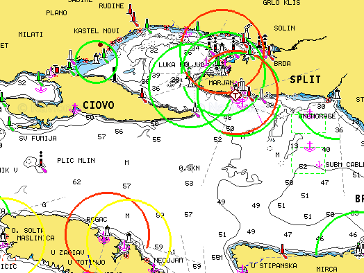
The electronic chart is an aid to navigation designed to facilitate the use of authorized government charts, not to replace them. Only official government charts and notices to mariners contain all information needed for the safety of navigation, and as always, the captain is responsible for their prudent use.
- Marine map viewer
NV charts
- NV charts catalogue
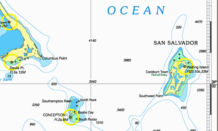
NV charts are especially designed with the requirements of the yachts-man in mind. Areas covered by NV charts: In Europe the Baltic Seas from Skagen bis Riga, the Norwegian south coast from Oslo to Haugesund, the German North Sea, the Dutch coast and inland waters, the English Channel, the French Atlantic coast and in the Mediterranean Sea to Naples, Croatia and Greece. The US East Coast, the Caribbean from the Bahamas to Cuba, the Virgin Islands and down to Grenada (2020).
- Boat View
View online charts / Cartes marines consultables en ligne
Not for navigational use / Ne pas utilisez pour la navigation
Your free online harbour guide for all of Europe with wonderful functions for planning the voyage of sail boats and motor boats. Share your experiences with other sailors and make your time on the water the best of the year with boatview.io and using the NV Charts App as a powerful intuitive boating app with free online nautical charts for planning. Featured Regions: Northsea, Germany, Baltic Sea, Skagerak and Kattegat, Netherlands, Mediterranean, Atlantic Coast Europe, Atlantic Islands Europe. - Online NV Charts Web App
View online charts / Cartes marines consultables en ligne
Not for navigational use / Ne pas utilisez pour la navigation
Enjoy the NV Charts App also as an online web viewer chart app simply in your browser free of charge for planning a cruise or exploring a new sea area and as an online harbour and marina guide. By registering with the free NV Charts Web App online nautical chart app, you can also easily synchronize all data to your mobile devices and start navigating on board directly. NV Charts Web App is the online version of the popular NV Charts App and is the ideal complement to use on your mobile devices online in your browser featuring the latest chart data and intuitive operation. All community layer information with ports, harbours, anchorages, navigation waring, photos, shops and places of interest are displayed directly online in the NV Charts App, and information can also be added by you or commented. You can share your favorite harbors and anchorages from the marine navigation app by simply clicking on a link and coordinate your trip planning with everyone on board. Together with the NV Charts community website Seame.com a detailed planning tool is available right here. Featured Regions: Europe (Northsea, Germany, Baltic Sea, Skagerak and Kattegat, Netherlands, North Mediterranean Sea, Atlantic Coast Europe, Atlantic Islands Europe), USA East coast, Bahamas, Caribbean Sea. Need a free login. Maximum 15 minutes per day. - Downloads
Documents and software to download. Content: Chart Navigator Update, Chart Navigator Manual, NV Pocket Navigator Update, NV Pocket Navigator Manual, Digitale Waypoints Baltic, NV Islands Game, Chart Navigator Light.
- Latest reports
Whether under sail or motor - for anyone on the water, you will find many important changes such as depth structure and buoyage and loads of additional information such as lock times and harbour information. Latest reports are published on our website and are displayed directly in the NV Charts App with daily updates. The latest reports displayed on this website are grouped by products.

- NV charts catalogue
OpenSeaMap - The free nautical chart
OpenSeaMap is an open source, worldwide project to create a free nautical chart. There is a great need for freely accessible maps for navigation purposes, so in 2009, OpenSeaMap came into life. The goal of OpenSeaMap is to record interesting and useful nautical information for the sailor which is then incorporated into a free map of the world. This includes beacons, buoys and other navigation aids as well as port information, repair shops and chandlerys. OpenSeaMap is a subproject of OpenStreetMap and uses its database.

Portmaps
- Portmap
View online Navionics ENC charts / Cartes ENC Navionics consultables en ligne
Not for navigational use / Ne pas utilisez pour la navigation
Live Sea chart powered by Navionics (with port information, AIS or weather).
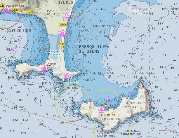
- Portmap

| | Document |


L'urgence prime la forme - By Cr - 2012-2024
For updates, corrections, new charts or new documents please send an e-mail to
For my father and my mother / Pour mon père et ma mère
