~ |
Online free nautical charts and publications
open data/open access - libre accès
Cartes marines gratuites et ouvrages nautiques en ligne
 | P |

| S | 
| ||
R
Russia/Russie
About Nautical Free
Nautical Free provides a list of free nautical charts and online publications.There is a list by country from letter A to letter V, for each country the organizations and for each organization a list of free online documents (charts, nautical books, notice to mariners...). There is two special lists: one for the international organizations and one for the private companies. There is also a reverse list by type of documents: sailing directions, radio signals, tide tables, nautical charts... You can also find on Nautical Free wave forecast maps for tomorrow, space weather forecast for GPS, how to check your computer clock, as well as information about celestial navigation or about ice navigation...
Au sujet de Nautical Free
Nautical Free fournit une liste de cartes marines gratuites et d'ouvrages nautiques en ligne.Il y a une liste par pays de la lettre A à la lettre V, pour chaque pays les organisations et pour chaque organisation une liste de documents libres en ligne (cartes marines, ouvrages nautiques, avis aux navigateurs...). Il existe deux listes spéciales : une pour les organisations internationales et une pour les sociétés privées. Il existe également une liste inverse par type de documents : instructions nautiques, ouvrages de radiosignaux, tables des marées, cartes marines... Vous trouverez également sur Nautical Free des cartes de prévision de la hauteur des vagues pour demain, des prévisions de la météo de l'espace pour les GPS, comment vérifier l'heure de son ordinateur, ainsi que des informations sur la navigation astronomique ou la navigation dans les glaces...
Advice / Conseils
For navigation use only updated regulatory documents /
Pour la navigation n'utiliser que des documents réglementaires à jour.
GPS is more accurate than nautical charts /
Un GPS est plus précis qu'un carte marine
Web Servers / Serveurs Web
You can use the nearest or faster server / Vous pouvez utiliser le serveur le plus proche ou le plus rapide :
- French mirror with one page by section / Serveur en France avec une page par section : http://nauticalfree.free.fr
- French mirror on one page / Serveur en France sur une page : http://nauticalfree.free.fr/onepage.html
- French mirror without image on one page / Serveur en France sans image sur une page : http://nauticalfree.free.fr/noimage/
- US mirror with one page by section / Serveur au États-Unis avec une page par section : http://nauticalfree.eu5.org
- US mirror on one page / Serveur au États-Unis sur une page : http://nauticalfree.eu5.org/onepage.html
- US mirror without image on one page / Serveur au États-Unis sans image sur une page : http://nauticalfree.eu5.org/noimage/
- US mirror on seven pages / Serveur au États-Unis sur sept pages : https://sites.google.com/site/nauticalfree/
Caption / Légende
- The nautical books are in standard fonts / Les ouvrages sont en caractères droits
- In Italic the maps and the charts / Les cartes sont en italiques
- The last item for an organization is the Notices to Mariners. The first issue of each year is often a special publication /
La dernier item pour un service hydrographique est un lien vers les avis au navigateurs. Le premier numéro de chaque année est souvent un numéro spécial
- Raster Navigational Charts (RNC)
- Bitmap electronic images of paper charts that conform to IHO standard S-61 /
Carte marine matricielle, fac-similé numérique d'une carte papier (scan) conforme à la norme de l'OHI S-61 - Electronic Navigational Charts (ENC)
- Vector charts that conform to IHO standard S-57 /
Carte électronique de navigation, carte vectorielle conforme à la norme de l'OHI S-57
|
|
Cartes marines gratuites et ouvrages nautiques en ligne : Russie
R
Russian Federation / Fédération de Russie
- Главного управления навигации и океанографии (ГУНиО МО РФ)
- Information and Analysis Center (IAC)
- Northern Sea Route General Administration (NSR)
- Arctic and Antarctic Research Institute (AARI)
- Russian Federal Service for Hydrometeorology and Environmental Monitoring (Roshydromet)
Главного управления навигации и океанографии - ГУНиО МО РФ (Head Department of Navigation and Oceanography - HDNO)
- Извещения мореплавателям
Извещения мореплавателям издаются Управлением навигации и океанографии Минобороны России еженедельными выпусками. В выпусках ИМ УНиО Минобороны России публикуется навигационная информация, предназначенная для поддержания на уровне современности морских навигационных карт, лоций и других руководств для плавания, полученная из иностранных и российских источников. Нумерация извещений сквозная в течение календарного года. Выпуски извещений датируются субботой, соответствующей неделе готовности печатных версий ИМ УНиО.
- Извещения мореплавателям Выпуск 2022
СОДЕРЖАНИЕ: 1. Перечень морских портов, открытых для захода иностранных судов - 2. Сведения о режиме работы радиостанций в морских портах, открытых для захода иностран-ных судов - 3. Перечень морских портов, имеющих станции для обслуживания надувных спасательных плотов производства РФ - 4. Правила подачи сигналов пограничными кораблями и летательными аппаратами ПС ФСБ России для остановки невоенных судов в территориальном море и внутренних морских водах РФ - 5. О сигналах для предупреждения иностранных военных кораблей о нарушении пра-вил захода, плавания и пребывания в территориальном море и внутренних морских водах РФ...
- Навигационные предупреждения
В еженедельном Бюллетене навигационных предупреждений публикуются тексты НАВАРЕА, НАВИП и ПРИП (на регионы России), объявленных за истекшую неделю и перечни номеров действующих НАВАРЕА, НАВИП и ПРИП. Перечни номеров и тексты действующих НАВАРЕА, НАВИП и ПРИП публикуются один раз в квартал в Бюллетенях к выпускам 2, 15, 28 и 41 ИМ УНиО МО. В текстах НАВАРЕА, НАВИП и ПРИП указывается Всемирное координированное время (цТС) В случае необходимости может быть указано другое время (поясное или местное) и тогда это оговаривается.
- Navigational warnings for NAVAREA XIII
Navigational warnings for NAVAREA XIII: North Japan sea (Valdivostok), Sea of Okhostsk (Okhostsk, Magadan, Petropavlovsk).
- Notices to mariners
Extracts from original Russian Notices to Mariners. Notices to Mariners from Section II "Charts Correction", based on the original source information, and NAVAREA XIII, XX and XXI navigational warnings are reprinted hereunder in English. Original Notices to Mariners from Section I "Miscellaneous Navigational Information" and from Section III "Nautical Publications Correction" may be only briefly annotated and/or a reference may be made to Notices from other Sections. Information from Section IV "Catalogues of Charts and Nautical Publications Correction" concerning the issue of charts and publications is presented with details.

- Извещения мореплавателям
Information and Analysis Center (IAC) / Информационно-аналитический центр (ИАЦ)
- GLONASS/ГЛОНАСС constellation status
GLONASS/ГЛОНАСС status: Total satellites in constellation - In operation - In commissioning phase - In maintenance - Under check by the Satellite Prime Contractor - Spares - In flight tests phase.
- GLONASS/ГЛОНАСС: 24 hours status monitoring
24 hours GLONASS/ГЛОНАСС status monitoring according to the global network of stations' data.
Usable No data Incorrect data
Unhealthy Not enough data Failure (URE > 50 m) - Notice Advisory to GLONASS/ГЛОНАСС Users (NAGU)
NAGU information group (СПСГ).
- GLONASS/ГЛОНАСС Instant Availability (PDOP)
Map with the current values of position geometry factor PDOP on the Earth surface (angle ≥ 5°, UTC+3). The PDOP value indicates the quality of a GNSS position. It takes account of the location of each satellite relative to the other satellites in the constellation, and their geometry in relation to the GNSS receiver. The smaller the PDOP, the higher the positioning accuracy: PDOP value of 4 or less gives excellent positions, a PDOP of between 4 and 8 is acceptable and a PDOP of 8.0 or more is poor. The maximum recommended PDOP value is 6. Also maps with the number of GNSS satellites.
GLONASS/ГЛОНАСС: Current position dilution of precision (PDOP), UTC+3 - If empty reload the image- GPS constellation status
GPS status: Total satellites in constellation - Operational - In commissioning phase - In maintenance - In decommissioning phase.
- GPS 24 hours status monitoring
24 hours GPS status monitoring according to the global network of stations' data.
- GPS Instant Availability (PDOP)
Map with the current values of position geometry factor PDOP for GPS on the Earth surface (angle ≥ 5°, UTC).
- Galileo constellation status
Galileo status: Total satellites in constellation - Operational - Not operational.
- Galileo 24 hours status monitoring
24 hours Galileo status monitoring according to the global network of stations' data.
- Galileo Instant Availability (PDOP)
Map with the current values of position geometry factor PDOP for Galileo on the Earth surface (angle ≥ 5°, UTC).
- Beidou constellation status
Beidou status: Total satellites in constellation -In geostationary orbit (GEO) - In inclined geosynchronous orbits (GIO) - In medium circular orbits (MEO) - Operational - Not operational.
- Beidou 24 hours status monitoring
24 hours Beidou status monitoring according to the global network of stations' data.
- Beidou Instant Availability (PDOP)
Map with the current values of position geometry factor PDOP for Beidou on the Earth surface (angle ≥ 5°, UTC).
- Navigation systems user performance
User performance diagrams for GLONASS, BeiDou, GLONASS+ BeiDou, GPS, Galileo navigation systems are shown in the section: Number of GNSS satellites, Position dilution of precision for a GNSS user (PDOP), Signal-in-Space User Accuracy (SIS UA), Signal-in-Space Ranging Error (SISRE).s

- GLONASS/ГЛОНАСС constellation status
The Northern Sea Route General Administration (NSR) / Главное управление Северного морского пути» (ФГБУ «ГлавСевморпуть»)
- Rules of navigation in the water area of the Northern Sea Route
Rules of navigation on the water area of the Northern Sea Route establish the order of the organization of navigation of ships, rules of the icebreaker assistance, rules of the ice pilotage of ships, rules on the track assistance of ships, provision on the navigational hydrographic and hydrometeorological support, rules of the radio communication, requirements to ships in relation to the safety of navigation and protection of the marine environment against the pollution from ships, other provisions relative to the organization of the navigation of ships in the water area of the Northern Sea Route.
- Recomendations about the communication for the period of the Arctic navigation
Recommendations on communication are advised for all ships navigating in the water area of the Northern Sea Route as well as for coastal radio centers and radio stations providing radio communication with ships (VHF/MF/HF/satellite).
Ice concentration for the Kara Sea (Russia) Type of ice conditions for the Kara Sea (Russia) - Icebreaker assistance value calculating
This calculator is based on the tariffs and application rules, which established by the Federal Service for Tariffs of the Russian Federation exclusive of VAT and can be suitable only for service carried out by the FSUE "Atomflot".
- Ice Information
- Types of ice conditions: ice free, light, medium or heavy - 3 days forecasts for the Russian Arctic sea
- Arctic ocean charts of ice conditions: ice analysis based son atellite imagery with stage of development (thickness)
- Long-term ice forecasts for the Russian Arctic seas
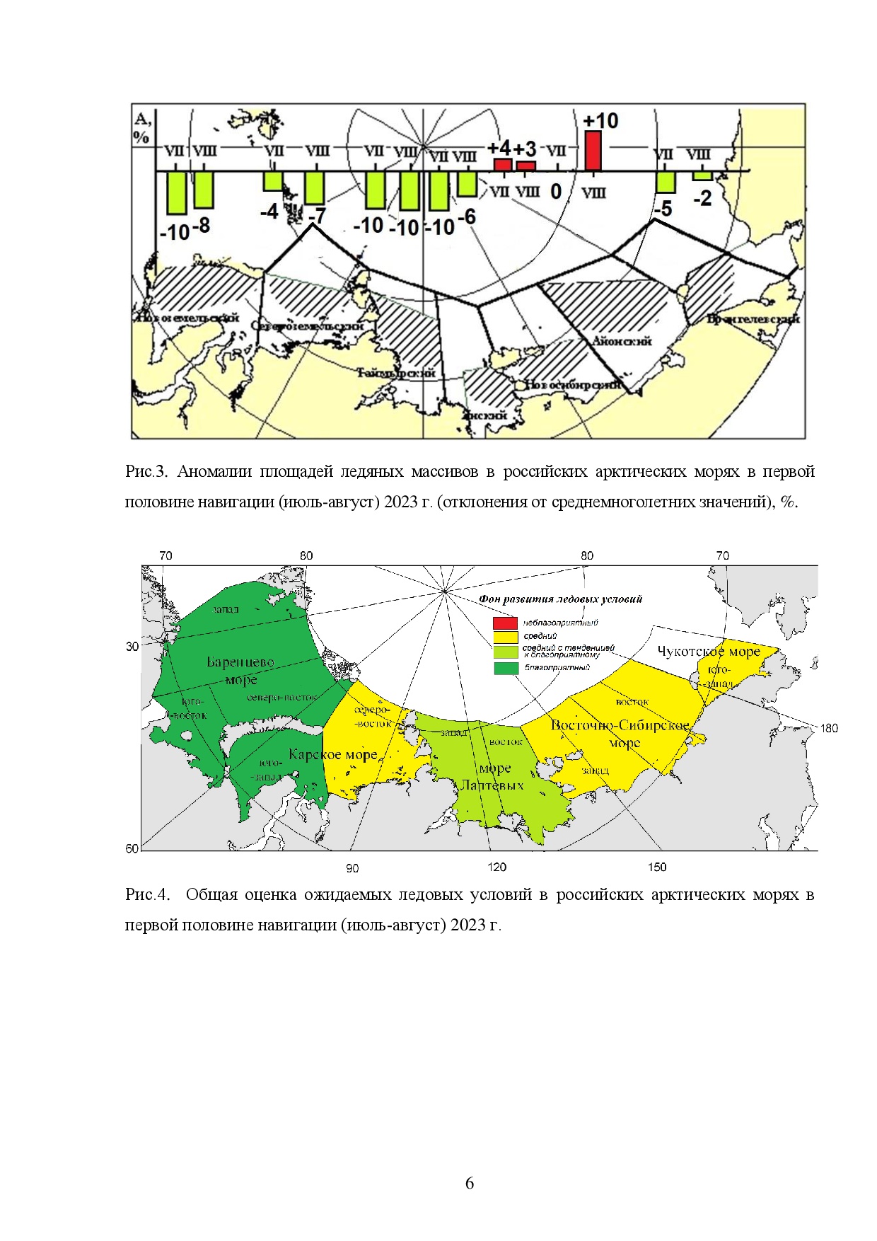
Expected ice conditions in the Russian Arctic Seas from July to August 2023 - Northern Sea route MRCC
For the Northern Sea route: List of maritime rescue coordination center (MRCC) - List of icebreakers - List of pre-positioned oil spill response resources.

- Rules of navigation in the water area of the Northern Sea Route
Arctic and Antarctic Research Institute (AARI) / Арктический и антарктический научно-исследовательский институт (ААНИИ)
- Review ice charts
Review ice charts of the Arctic Ocean are posted here. Scale of hardcopy corresponds to 1:10 000 000. During summer period (1.VI-30.IX) charts depict distribution of generalized categories of sea ice total concentration for the intervals 1-6/10s and 7-10/10s, during winter period (1.XI-31.V) - distribution of generalized sea ice stages of development (ice thickness) - nilas, young, first-year and old ice. Data collection (averaging) is done for preceding 2-5 days interval. Ice charts are issued every Thursday. Ice charts are based on automatical generalization of regional ice charts which are compiled on a basis of analysis of satellite (visible, infra-red and radar) information and reports from coastal stations and ships.
- Arctic Ocean ice charts: ice analysis from satellite imagery with predominant stage(s) of development (thickness)
- Regional ice charts for the Eurasian Arctic, Northern Pacific, Caspian and Baltic Seas: Greenland, Baltic, Barents, Kara, Laptev, East Siberian, Chukchi, Bering, Okhotsk, Caspian
- Arctic Ocean ice charts: ice analysis from satellite imagery with predominant stage(s) of development (thickness)
- Карты ледовой обстановки
Представлены комплексные карты ледовой обстановки арктических и замерзающих морей России. Масштаб твердой копии соответствует 1:5 000 000. В летний период (1.06-30.09) карты отражают распределение льда по обобщенным градациям сплоченности 1-3, 4-6, 7-8 и 9-10 баллов, в зимний период (1.11-31.05) - распределение льда по градациям возраста (толщины льда) - ниласовые, молодые, однолетние (тонкие, средние, толстые) и старые. Сбор (осреднение) информации выполняется за 2-5-ти суточный период. Карты составляются по данным ИСЗ (видимый, ИК-диапазоны, радарные снимки), судов и полярных станций.
- Обзорные ледовые карты СЛО: Анализ ледовой обстановки по данным исз
- Региональные ледовые карты: Гренландско, Балтийское, Баренцево, Карское, Лаптевых, Восточно-сибирское, Чукотское, Берингово, Охотское, Каспийское.
- Обзорные ледовые карты СЛО: Анализ ледовой обстановки по данным исз
Arctic Ocean ice chart - Northeast passage - Collaborative Antarctic Ice Charts (AARI-NIC-NMI)
Antarctic ice charts from Norwegian Ice Service (NIS-NMI), U.S. National Ice Center (NIC), and Russian Arctic and Antarctic Research Institute (AARI). Charts for the whole of Antarctica (concentration and stage of development) are updated on Thursdays throughout the year. During the Antarctic summer (October to April) detailed ice charts for: Antarctic Peninsula, Weddell Sea East, Bransfield Strait and Adelaide Island. Current map for the Antarctic Peninsula.
- Russian Glossary of Sea Ice Terminology (English Edition)
Any field of science, and ice science is no exception, has its own terminology, i.e., a set of terms, words and expressions, which continuously develops and becomes more perfect. The present glossary of sea ice terminology is a first attempt to systemize in one- volume terms related to ice and its properties, to the properties of ice sheets, to ice forecasting, and to the scientific and operational support of ice navigation. We have attempted to keep the English edition of this glossary as close to the Russian original as possible.
- Sea-ice terms
- Glossary of the sea-ice terms: Russian-English - English-Russian
- Ice terms arranged by subject: In English - In Russian
- Ледовые термины, расположенные в тематическом порядке
- Online WMO documents
- ЛЕДОВЫЕ УСЛОВИЯ ПЛАВАНИЯ В ЮЖНОМ ОКЕАНЕ - ВМО/ТД- No. 783, 1996
- Sea Ice Nomenclature - WMO-No. 259 (Draft Version 1.0), 2005
- Electronic version of the WMO Sea-Ice nomenclature - English, French, Russian and Spanish versions in alphabetic/subject order, equivalents, search/selection option (WMO/AARI)
- Sea-ice symbols on charts
- Ice chart colour code standard - WMO/TD- No. 1215 & JCOMM TD- No. 24, 2004
- Ice symbols in oval shapes and ice maps - JCOMM, 2005
- Элементам ледовой символики в овальной фигуре и ледовой карте - JCOMM, 2005
- SIGRID (Sea Ice Grid): a vector format for archiving digital ice charts
- Review ice charts
Russian Federal Service for Hydrometeorology and Environmental Monitoring (Roshydromet) / Федеральная служба по гидрометеорологии и мониторингу окружающей среды (Росгидромет)
- Руководство по гидрометеорологическому обеспечению морской деятельности
В настоящем Руководстве изложены вопросы организации гидрометеорологического обеспечения морских отраслей экономики в свете современных требований практики и взаимоотношений с потребителями с учетом действующих в Росгидромете нормативно-правовых и научно-методических документов. Руководство предназначено, в первую очередь, для специалистов Росгидромета, занятых в области гидрометеорологического обеспечения морских отраслей экономики, а также для круга специалистов, занимающихся морской деятельностью.
- Терминология прогнозов погоды: краткосрочных прогнозах погоды и штормовых предупреждениях
- Шкала Бофорта: Сила ветра у земной поверхности по шкале Бофорта
- Атлас облаков
Атлас как справочное методическое пособие предназначен для работников метеорологических наблюдательных и прогностических подразделений Федеральной службы по гидрометеорологии и мониторингу окружающей среды (Росгидромета), специалистов Гидрометеорологической службы Минобороны РФ. Он может быть использован также в качестве учебного пособия для преподавателей, аспирантов и студентов высших учебных заведений гидрометеорологического и географического профиля, учащихся техникумов и слушателей курсов повышения квалификации метеорологов.
- Satellite images & maps of ice coverage conditions (SRC Planeta)
Satellite Digital RGB-synthesized geocoded images conditions and digital chart maps of ice coverage conditions. Legend in Russian. Go to section "Ice cover". Areas: Antarctic region - Baltic Sea - Barents Sea - White Sea - Bering Sea 1 - Bering Sea 2 - Eastern-Siberian Sea 1 - Eastern-Siberian Sea 2 - Kara Sea 1 - Kara Sea 2 - Caspian Sea - Laptev Sea 1 - Laptev Sea 2 - Laptev Sea 3 - Okhotsk Sea 1 - Okhotsk Sea 2 - Russian sector of Arctic region - Northern hemisphere - Black and Azov seas - Chukotsk Sea 1 - Chukotsk Sea 2 - Sea of Japan 1 - Sea of Japan 2 - Yellow Sea (SRC Planeta).
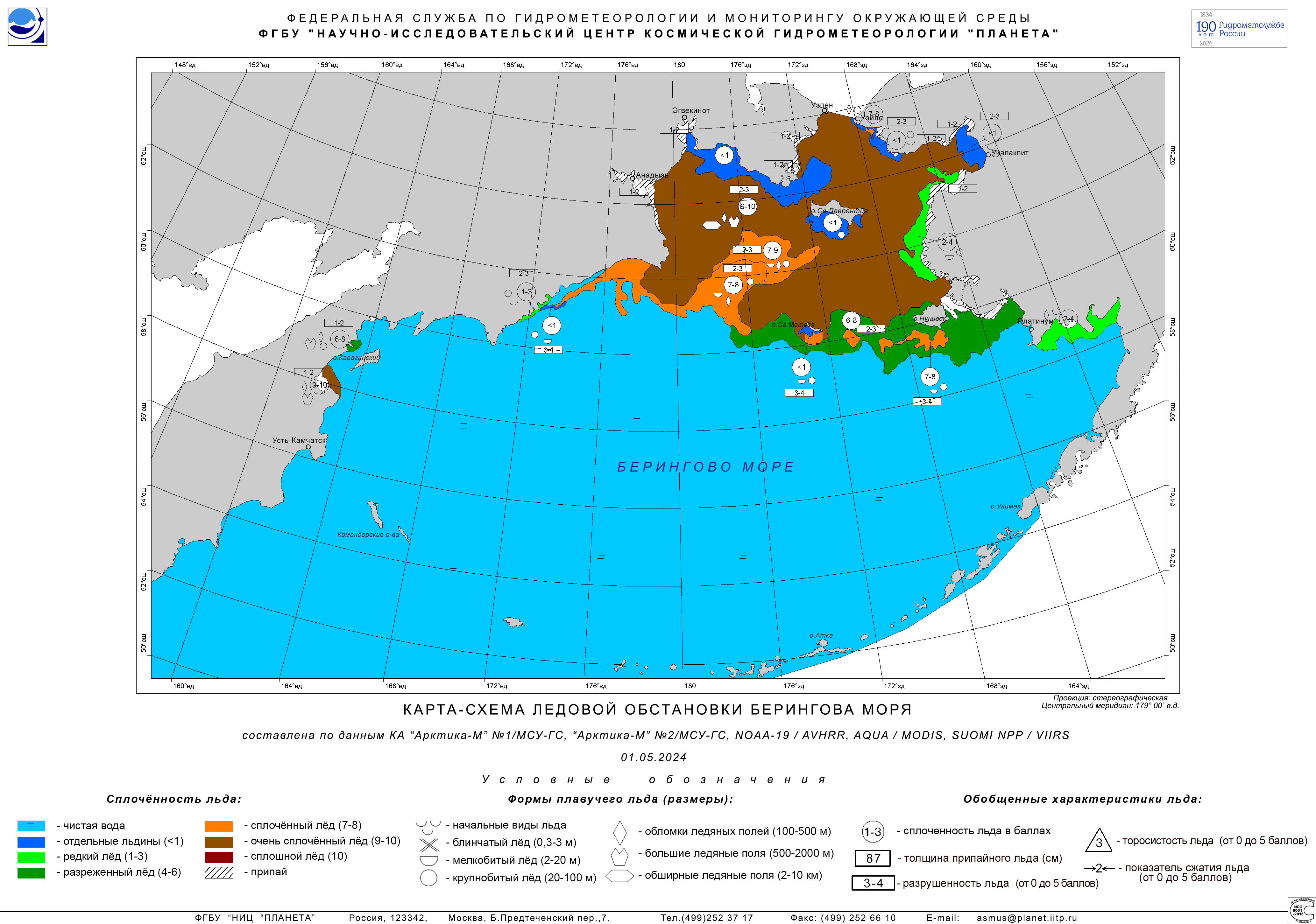
Bering Sea: Ice coverage map / Берингово море - карта-схема ледового покрова - Текущее состояние ледового покрова на морях
Цветовыми градациями показана доля морской поверхности, занятой льдом (0 баллов - чистая вода, 10 баллов - сплошной лед). Карта с данными за прошедшие сутки обновляется ежедневно около 4 час ВСВ (всемирное скоординированное время, совпадающее с временем по Гринвичу).Данные, используемых спутниковых измерений, имеют пространственное разрешение около 50 км. В прибрежной зоне возможны большие погрешности в определении сплоченности льда из-за искажающего влияния суши на получаемый спутниковый сигнал. Моря : Баренцево море - Балтийское море - Белое море - Берингово море - Каспийское морe - Охотское море - Японское море - Арктике - Антарктике (ЕСИМО - Гидрометцентр Росси)
Ice maps: Barents Sea - Baltic Sea - White Sea - Bering Sea - Caspian Sea - Sea of Okhotsk - Sea of Japan - Arctic - Antarctic. - Состояние ледового покрова моря
Информация обновляется еженедельно по пятницам (в течение ледового периода года). Моря: Арктике - Антарктике - Азовское море - Баренцево море - юго-восточной Баренцева моря - Баренцево море - Охотское море (данные ИСЗ) - Охотское море (анализ) - Японское море - Балтийское море - Белое море - Каспийское море (ЕСИМО - Гидрометцентр Росси)
Ice maps: Arctic - Antarctic - Azov Sea - Barents Sea - Bering Sea - Sea of Okhotsk - Sea of Japan - Baltic Sea - White Sea - Caspian Sea. - Global forecast of ocean wave parameters
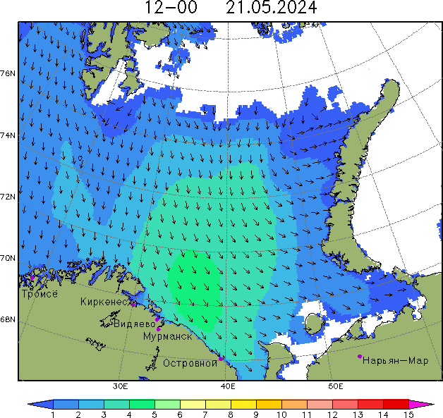
Wave forecast for the ocean. Forecast Field: Significant Wave Height (Wind Waves and Swell) - Significant Wave Height and Direction for Wind Waves - Significant Wave Height and Direction for Swell... The wave height is given in meters. Lead Time: 12hr to 72hr (Hydrometcentre of Russia and Arctic and Antarctic Research Institute).
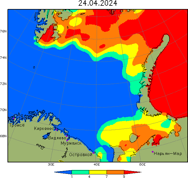
Barents Sea: Ice Concentration Chart
Сплоченность льда в Баренцевом море (юго-восточной)Barents Sea: Wave forecast for tomorrow (Height in metres)
Прогноз параметров ветрового волнения- Прогноз параметров ветрового волнения
Высота преобладающих волн и направление распространения. На карте цветом обозначена высота преобладающих волн (м). Отдельные волны могут превышать приводимые значения. Стрелками показано среднее направление распространения волн (только для областей с высотой волн более 5 см). Сведения о прогностической системе. Регион: Азовское море - Баренцево море - Балтийское море - Белое море - Каспийское море - Чёрное море - Мировой океан - Атлантика, северная часть - Атлантика, южная часть - Тихий океан, северная часть - Тихий океан, южная часть - Индийский океан (ЕСИМО - Гидрометцентр Росси).
Wave maps: Azov Sea - Barents Sea - Baltic Sea - White Sea - Caspian Sea - Black Sea - World map - Atlantic: northern & southern part - Pacific Ocean: northern & southern part - Indian Ocean.
Берингово море: Смешанное волнение: высота (м) и направление
Bering Sea: Wave forecast for tomorrow (UTC) - Height in metres- Прогноза смешанного волнения на дальневосточных морях и в Тихом океане
Смешанное волнение: высота (м) и направление. Прогноз на основе численной модели WW III является результатом научных исследований, проводящихся в ФГБУ "ДВНИГМИ". Моря: Тихий океан - Индийский океан - Японское море - Залив Петра Великого - Татарский пролив - Охотское море - Тауйская губа - Берингово море - Восточная Артика (Восточно-Сибирское, Чукотское моря).
Wave maps: Pacific Ocean - Indian Ocean - Japanese Sea - Gulf of Peter the Great - Tatar Strait - Sea of Okhotsk - Taui Bay - Bering Sea - Eastern Arctic (East Siberian, Chukchi Sea).
- Руководство по гидрометеорологическому обеспечению морской деятельности
| | S |


L'urgence prime la forme - By Cr - 2012-2024
For updates, corrections, new charts or new documents please send an e-mail to
For my father and my mother / Pour mon père et ma mère


