~ |
Online free nautical charts and publications
open data/open access - libre accès
Cartes marines gratuites et ouvrages nautiques en ligne
 | Document |

|
Miscellaneous Maritime Informations/ Informations maritimes diverses
AIS, VTS, METAREA...
About Nautical Free
Nautical Free provides a list of free nautical charts and online publications.There is a list by country from letter A to letter V, for each country the organizations and for each organization a list of free online documents (charts, nautical books, notice to mariners...). There is two special lists: one for the international organizations and one for the private companies. There is also a reverse list by type of documents: sailing directions, radio signals, tide tables, nautical charts... You can also find on Nautical Free wave forecast maps for tomorrow, space weather forecast for GPS, how to check your computer clock, as well as information about celestial navigation or about ice navigation...
Au sujet de Nautical Free
Nautical Free fournit une liste de cartes marines gratuites et d'ouvrages nautiques en ligne.Il y a une liste par pays de la lettre A à la lettre V, pour chaque pays les organisations et pour chaque organisation une liste de documents libres en ligne (cartes marines, ouvrages nautiques, avis aux navigateurs...). Il existe deux listes spéciales : une pour les organisations internationales et une pour les sociétés privées. Il existe également une liste inverse par type de documents : instructions nautiques, ouvrages de radiosignaux, tables des marées, cartes marines... Vous trouverez également sur Nautical Free des cartes de prévision de la hauteur des vagues pour demain, des prévisions de la météo de l'espace pour les GPS, comment vérifier l'heure de son ordinateur, ainsi que des informations sur la navigation astronomique ou la navigation dans les glaces...
Advice / Conseils
For navigation use only updated regulatory documents /
Pour la navigation n'utiliser que des documents réglementaires à jour.
GPS is more accurate than nautical charts /
Un GPS est plus précis qu'un carte marine
Web Servers / Serveurs Web
You can use the nearest or faster server / Vous pouvez utiliser le serveur le plus proche ou le plus rapide :
- French mirror with one page by section / Serveur en France avec une page par section : http://nauticalfree.free.fr
- French mirror on one page / Serveur en France sur une page : http://nauticalfree.free.fr/onepage.html
- French mirror without image on one page / Serveur en France sans image sur une page : http://nauticalfree.free.fr/noimage/
- US mirror with one page by section / Serveur au États-Unis avec une page par section : http://nauticalfree.eu5.org
- US mirror on one page / Serveur au États-Unis sur une page : http://nauticalfree.eu5.org/onepage.html
- US mirror without image on one page / Serveur au États-Unis sans image sur une page : http://nauticalfree.eu5.org/noimage/
- US mirror on seven pages / Serveur au États-Unis sur sept pages : https://sites.google.com/site/nauticalfree/
Caption / Légende
- The nautical books are in standard fonts / Les ouvrages sont en caractères droits
- In Italic the maps and the charts / Les cartes sont en italiques
- The last item for an organization is the Notices to Mariners. The first issue of each year is often a special publication /
La dernier item pour un service hydrographique est un lien vers les avis au navigateurs. Le premier numéro de chaque année est souvent un numéro spécial
- Raster Navigational Charts (RNC)
- Bitmap electronic images of paper charts that conform to IHO standard S-61 /
Carte marine matricielle, fac-similé numérique d'une carte papier (scan) conforme à la norme de l'OHI S-61 - Electronic Navigational Charts (ENC)
- Vector charts that conform to IHO standard S-57 /
Carte électronique de navigation, carte vectorielle conforme à la norme de l'OHI S-57
|
|
III - Miscellaneous maritime informations / Informations maritimes diverses
- OpenCPN: Software for marine navigation
- qtVlm : Logiciel de navigation et de routage
- OpenSeaMap: The free nautical chart
- Inland Waters Resources: Free charts of inland rivers
- The Nautical Almanac: Free celestial navigation information
- Marine Traffic: Worldwide AIS map
- Fédération Nationale des Associations de Pensionnés de la Marine Marchande (FNPMM): associations of pensioners
- RNT Fondation: Prevent impact of space weather and cyber-attack on GNSS
- DeckOfficer.ru: информации которая пригодится Вам в учебе, а также при трудоустройстве...
- Admiralty EasyTide: Worldwide tidal predictions in English
- Horaires des marées (SHOM): Worldwide tidal predictions in French
- MARC: Coastal observations and forecasts for the coastlines of France & Overseas (Formerly PREVIMer)
- Ice Logistics Portal: Sea ice information
- Met Mar : Revue de météorologie maritime de Météo-France
- Severe Weather Information Centre: Centralized web site for severe weather around the world
- METAREA: Worldwide weather forecasts
- NAVAREA: Worldwide navigational warnings
- Search and Rescue Contacts: Find rescue coordination centres worldwide
- Medical Guides for Ships: for non-doctors
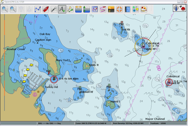
OpenCPN: Raster and Vector Chart Display
OpenCPN is free, open source software for marine navigation. It is available for Mac OSX, Microsoft Windows, GNU/Linux, BSDs and Solaris. OpenCPN: A concise ChartPlotter/Navigator. A cross-platform ship-borne GUI application supporting: GPS/GPDS Postition Input, BSB Raster Chart Display, S57 Vector ENChart Display, AIS Input Decoding, Waypoint Autopilot Navigation (More information about Chart Formats).
qtVlm : Logiciel de navigation et de routage
qtVlm est un logiciel de navigation pour bateaux à voile. C’est également un lecteur de grib gratuit qui accepte la plupart des formats et sources. Il permet l’affichage de cartes d’un grand nombre de formats : vectorielles (S57 et S63), raster (kaps, geotiff, …), cartes de Visit My Harbour et mbtiles. qtVlm est certifié Iridium GO! et peut également accéder directement à vos abonnements de gribs Great Circle (squid). Il inclut un module AIS (avec la possibilité de récupérer des cibles via internet) et un Module Instruments qui peut se connecter à différentes sources NMEA ou à un GPS interne. Il peut envoyer des données performance (VMG, vitesse cible, …) à un système de navigation ou aux afficheurs extérieurs. qtVlm est gratuit sur Windows, MacOS, Linux et Raspberry.
OpenSeaMap - The free nautical chart
OpenSeaMap is an open source, worldwide project to create a free nautical chart. There is a great need for freely accessible maps for navigation purposes, so in 2009, OpenSeaMap came into life. The goal of OpenSeaMap is to record interesting and useful nautical information for the sailor which is then incorporated into a free map of the world. This includes beacons, buoys and other navigation aids as well as port information, repair shops and chandlerys. OpenSeaMap is a subproject of OpenStreetMap and uses its database.
Inland Waters Resources: free charts of inland rivers
Links to free inland vector charts of Austria, Belgium, Croatia, Czech Republic, France, Hungary, Romania, Netherlands, Serbia, Switzerland, USA... By Dacust.
The Nautical Almanac
The free online Nautical Almanac. The world's most complete source of free celestial navigation information: Almanacs, Increments, Altitude & Q Corrections, Sight Reduction Tables, Stars...
Marine Traffic / AIS map
Ths web site provides free real-time information to the public, about ship movements and ports, mainly across the coast-lines of many countries around the world. The project is currently hosted by the University of the Aegean, Greece. The initial data collection is based on the Automatic Identification System (AIS).
Marine Traffic: Brittany/Bretagne, France (AIS) Marine Traffic: Brittany/Bretagne, France (AIS) Fédération Nationale des Associations de Pensionnés de la Marine Marchande (FNPMM)
La FNPMM est une fédération régie par la loi du 1° juillet 1901, regroupant les associations de pensionnés de la Marine Marchande (commerce et pêche). La fédération a pour buts de resserrer et de développer les liens de solidarité entre tous les pensionnés ainsi que de défendre les intérêts des pensionnés et de leurs ayants droit. L'information aux adhérents se fait principalement par Le Demi-Soldier, organe trimestriel d'information de la fédération qui paraît quatre fois pas an.
Resilient Navigation and Timing Foundation
Much of the world depends upon satellite systems for precise navigation and timing services. These are exceptionally accurate and dependable, yet GPS/GNSS jamming, spoofing, and other forms of interference appear to be growing in frequency and severity. Neither are space systems immune to severe space weather or cyber-attack. This has the potential for devastating effects on our lives and economic activity. Our goals of deterring jamming and spoofing while encouraging additional resilient services will protect critical infrastructure and make the world a safer place. Include a libray with some of the more important documents in the field.
DeckOfficer.ru
Библиотека Судоводителя - Морское Видео - Морской Софт - Позиция судов в реальном времени - Морские навигационные карты онлайн - Каталог морских навигационных карт - Расчет расстояний - Расчет приливов - Погода NAVTEX и Погода METAREA - Мореходная Астрономия - Вычисления с помощью Морского Астрономического Альманаха - Каталог Морских Сайтов - Морское Чтиво - Гостевой книге.
Admiralty EasyTide (UKHO)
The service provides tidal data for United Kingdom ports. Free predictions for the next 7 days with tidal curve.
Horaires des marées (SHOM)
Cette application permet de calculer la marée dans les principaux ports du monde et pour tous les ports, principaux et secondaires, de France métropolitaine. La référence de hauteur utilisée pour les prédictions de marée est le zéro des cartes qui, en général, correspond approximativement au niveau des plus basses mers (LAT : Lowest Astronomical Tide pour les Anglais). Il est possible d'insérez sur son propre site Internet les horaires de marée sous forme d'une vignette petite ou grande.
MARC : Modélisation et Analyse pour la Recherche Côtière
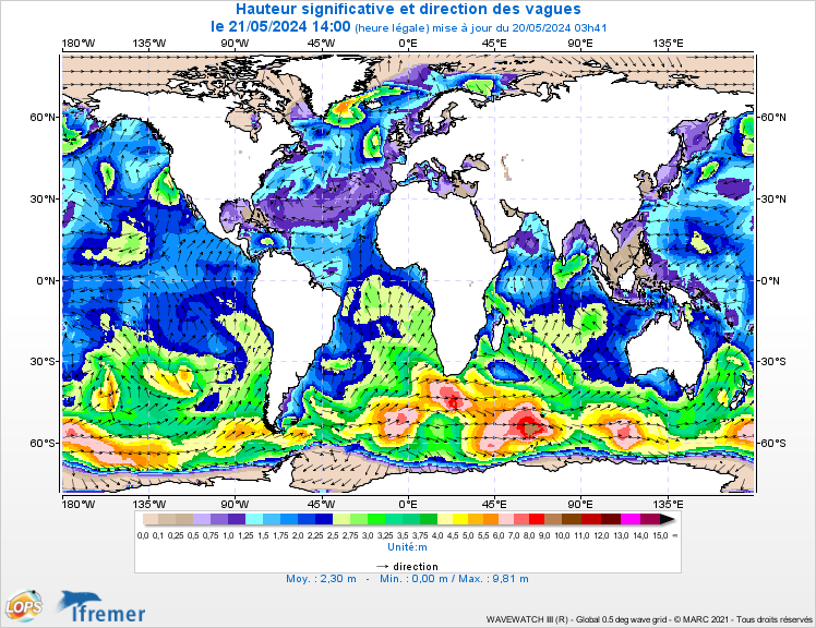
Coastal observations and forecasts for the coastlines of France & Overseas. MARC is a system aiming to provide a wide range of users, from private individuals to professionals, with daily observations and short-term forecasts about the coastal environment along the French coastlines bordering the English Channel, the Atlantic Ocean, and the Mediterranean Sea: currents, waves... All information contained on or available through this Web Site is for general information purposes only and does not constitute any investment advice. It can not be discerned or used with absolute reliability by anybody for a personal or professional activity such as maritime navigation. MARC does not replace offical forecast, warning and alert services nor official tide table predictions. Forecasts use French legal time. Maximum waves may be up to twice the significant height.
Forecasts of combined wave heights and directions for Day+1
Height in meters - French legal time (UTC+1/2)Ice Logistics Portal
The Ice Logistics Portal was created as a joint initiative of the International Ice Charting Working Group, the JCOMM Expert Team on Sea Ice and Polar View for the International Polar Year. It is now maintained by the German Bundesamt für Seeschifffahrt und Hydrographie. It is intended to create a convenient point of access to operational sea ice information produced by the world's ice services. Access to products is provided via a series of pre-defined regions for both the Arctic and the Antarctic. Since the primary focus of the Ice Logistics Portal is on operational sea ice data (i.e. ice charts), only the most recent information is displayed for any given region.
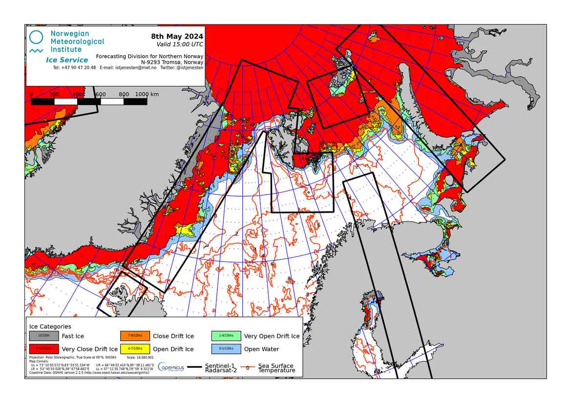
Ice chart for European Arctic. By the Cryo - Norwegian Ice Service Met Mar : Revue de météorologie maritime de Météo-France
Met Mar était une revue de vulgarisation de Météo-France dans le domaine de la météorologie maritime. Elle a été publiée de juillet 1953 à décembre 2007 (217 numéros). On y trouve des articles variés concernant la météorologie et le monde maritime : étude de situations météorologiques particulières - météorologie spatiale et tropicale - évolution des techniques pour l'étude et la prévision du temps - océanographie - actions d'assistance ou de promotion menées par Météo-France - grandes courses transocéaniques et jeux olympiques - récits...
Severe Weather Information Centre (WMO)
A centralized web site for severe weather around the world. This is a World Meteorological Organization (WMO) web site that provides a single and centralized source for tropical cyclones, heavy rain,
gale , fog and thunderstorms. For example whenever a tropical cyclone develops, a tropical cyclone symbol will show up on the front page of this website with both position and strength indications. Furthermore, users can make use of the links provided in this website to find more information about these tropical cyclones such as forecast tracks and warnings issued.METAREA: worlwide weather forecast (WMO)
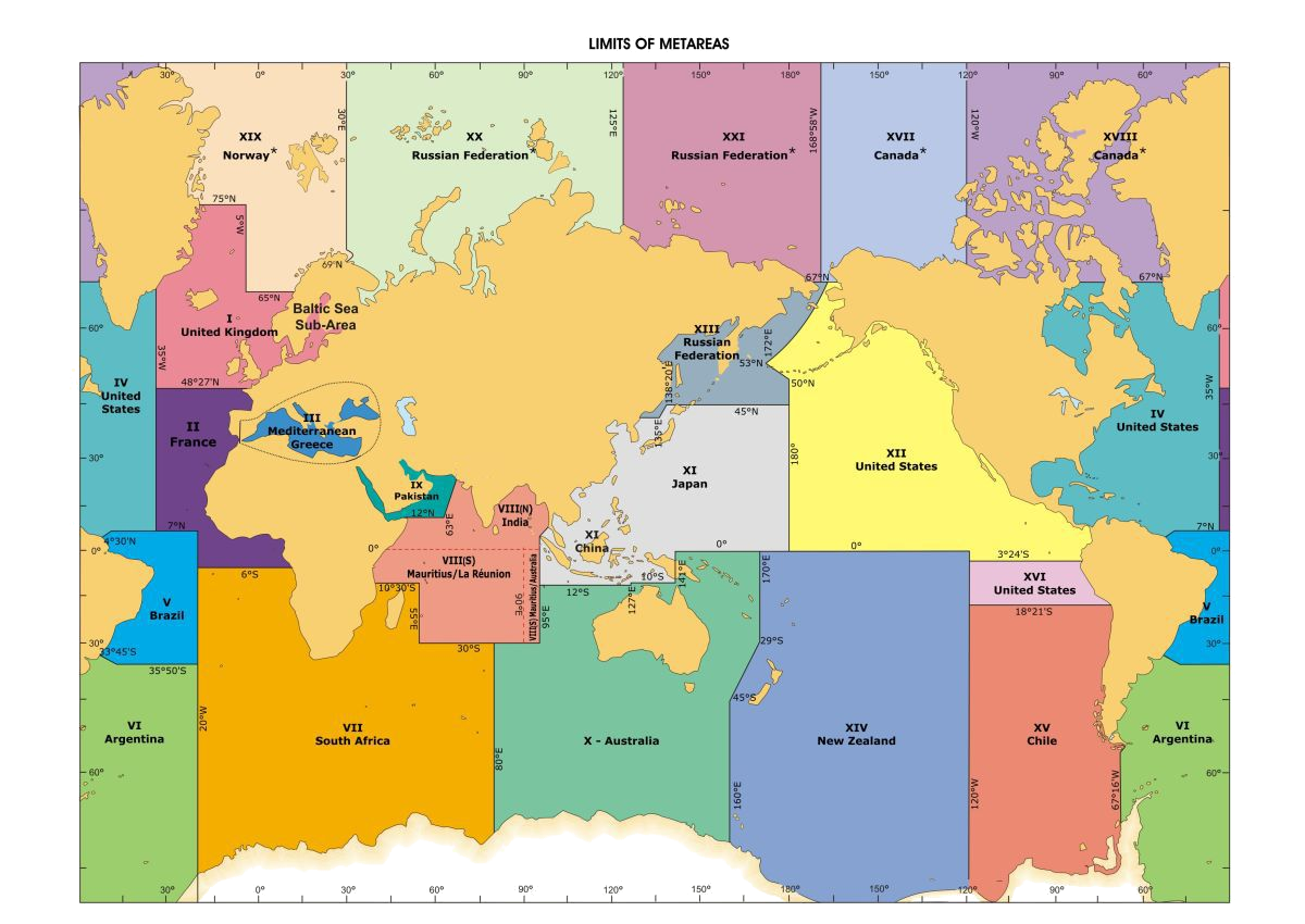
This website displays the marine meteorological warnings and meteorological forecast information that are provided to mariners via International Enhanced Group Call (EGC) Service and NAVTEX, as part of the World Meteorological Organization's (WMO) Worldwide Met-Ocean Information and Warning Service (WWMIWS), within the framework of the International Maritime Organization's (IMO) Global Maritime Distress & Safety System (GMDSS). The worlds' oceans have been divided into 21 areas, called METAREAS, for the provision of marine meteorological information and services to shipping.
NAVAREA: worlwide navigational warnings (IHO)
At the begin of the page the world static map (legacy) shows the limits of the 21 Operational NAVAREAs. Clicking on a NAVAREA title will take you to the NAVAREA Co-ordinators' website where Navigational Warnings are listed. At the end of the page click on the GIS map, the links to all NAVAREA Coordinators are also available. Note not all NAVAREA Co-ordinators publish warnings on the World Wide Web, some only provide Notice to Mariners.
Search and Rescue Contacts
Find Rescue Coordination Centres Worldwide. SAR contacts is a database of international search and rescue agencies and rescue coordination centres (MRCC: Maritime Rescue Coordination Centre, MRSC: Maritime Rescue Sub Centre, JRCC: Joint Rescue Coordination Centre...). The worldwide Search and Rescue Contacts website is managed by the Canadian Coast Guard in JRCC Halifax location.
Medical Guides for Ships
These manuals are written for non-doctors working on board a ship.They show how to diagnose, treat, and prevent the health problems of seafarers on board ship.
- The ship captain's medical guide (MCA/UK, 1999)
- The Ship's Medicine Chest and Medical Aid at Sea (DHHS/USA, 2003)
- International Medical Guide for Ships (WHO, 2007) - with a Quantification addendum
- Mariners Medico Guide - Software (NCMDM/Norway)
- ΔΙΕΘΝΗΣ ΙΑΤΡΙΚΟΣ ΟΔΗΓΟΣ ΓΙΑ ΠΛΟΙΑ (WHO/ΙΔΡΥΜΑ ΕΥΓΕΝΙΔΟΥ, 2011)
- Международное руководство по судовой медицине (B30, 2014) - Приложение
- Guía médica internacional de a bordo (OMS, 1989)
- Guía Sanitaria a Bordo (ISM, 2014)
- Guide médical international de bord (OMS, 1989)
| |


L'urgence prime la forme - By Cr - 2012-2024
For updates, corrections, new charts or new documents please send an e-mail to
For my father and my mother / Pour mon père et ma mère
