~ |
Online free nautical charts and publications
open data/open access - libre accès
Cartes marines gratuites et ouvrages nautiques en ligne
 | I |

| K | 
| ||
J
Japan/Japon
About Nautical Free
Nautical Free provides a list of free nautical charts and online publications.There is a list by country from letter A to letter V, for each country the organizations and for each organization a list of free online documents (charts, nautical books, notice to mariners...). There is two special lists: one for the international organizations and one for the private companies. There is also a reverse list by type of documents: sailing directions, radio signals, tide tables, nautical charts... You can also find on Nautical Free wave forecast maps for tomorrow, space weather forecast for GPS, how to check your computer clock, as well as information about celestial navigation or about ice navigation...
Au sujet de Nautical Free
Nautical Free fournit une liste de cartes marines gratuites et d'ouvrages nautiques en ligne.Il y a une liste par pays de la lettre A à la lettre V, pour chaque pays les organisations et pour chaque organisation une liste de documents libres en ligne (cartes marines, ouvrages nautiques, avis aux navigateurs...). Il existe deux listes spéciales : une pour les organisations internationales et une pour les sociétés privées. Il existe également une liste inverse par type de documents : instructions nautiques, ouvrages de radiosignaux, tables des marées, cartes marines... Vous trouverez également sur Nautical Free des cartes de prévision de la hauteur des vagues pour demain, des prévisions de la météo de l'espace pour les GPS, comment vérifier l'heure de son ordinateur, ainsi que des informations sur la navigation astronomique ou la navigation dans les glaces...
Advice / Conseils
For navigation use only updated regulatory documents /
Pour la navigation n'utiliser que des documents réglementaires à jour.
GPS is more accurate than nautical charts /
Un GPS est plus précis qu'un carte marine
Web Servers / Serveurs Web
You can use the nearest or faster server / Vous pouvez utiliser le serveur le plus proche ou le plus rapide :
- French mirror with one page by section / Serveur en France avec une page par section : http://nauticalfree.free.fr
- French mirror on one page / Serveur en France sur une page : http://nauticalfree.free.fr/onepage.html
- French mirror without image on one page / Serveur en France sans image sur une page : http://nauticalfree.free.fr/noimage/
- US mirror with one page by section / Serveur au États-Unis avec une page par section : http://nauticalfree.eu5.org
- US mirror on one page / Serveur au États-Unis sur une page : http://nauticalfree.eu5.org/onepage.html
- US mirror without image on one page / Serveur au États-Unis sans image sur une page : http://nauticalfree.eu5.org/noimage/
- US mirror on seven pages / Serveur au États-Unis sur sept pages : https://sites.google.com/site/nauticalfree/
Caption / Légende
- The nautical books are in standard fonts / Les ouvrages sont en caractères droits
- In Italic the maps and the charts / Les cartes sont en italiques
- The last item for an organization is the Notices to Mariners. The first issue of each year is often a special publication /
La dernier item pour un service hydrographique est un lien vers les avis au navigateurs. Le premier numéro de chaque année est souvent un numéro spécial
- Raster Navigational Charts (RNC)
- Bitmap electronic images of paper charts that conform to IHO standard S-61 /
Carte marine matricielle, fac-similé numérique d'une carte papier (scan) conforme à la norme de l'OHI S-61 - Electronic Navigational Charts (ENC)
- Vector charts that conform to IHO standard S-57 /
Carte électronique de navigation, carte vectorielle conforme à la norme de l'OHI S-57
|
|
Cartes marines gratuites et ouvrages nautiques en ligne : Japon
J
Japan / Japon
Japan Hydrographic and Oceanographic Department (JHOD/JCG)
- List of Charts and Publications (JHA)
- List of Paper Charts: Nautical Charts - Miscellaneous Charts
- Paper Charts Index Maps
- ENC: PDF catalogue - Web catalogue
- Interactive Search from Maps
- Chart Navi: Search the charts on your route
- List of Nautical Publications
- 現在使用できる海図 (日本水路協会)
航海用海図 ― 索引図 ― 特殊図 ― 水路書誌。
- S-66 電子海図とその船舶搭載要件の実際
電子海図 ガイドブック。 このガイドブックは、公式電子海図と非公式電子海図の違いや、船舶が電子海図を使用する際の要件、注意事項などを “質疑応答” 形式で取りまとめ解説した参考書です。 日本水路協会 ― 国際水路機関。分割ダウンロード。
- Tidal Data
Tidal Data with TOPS (Tide Observation & Prediction System). TOPS provides you with the tide prediction heights for a day at a port around the coastal of Japan. The system has nearly 330 ports including 71 standard ports in the tide table published by Japan Coast Guard. The system provides also the tidal current prediction with hourly velocities at three areas in Japan, that is, Tokyo bay, Ise bay and Seto inland sea.
Actual tidal current prediction for the Setonaikai area, Japan (UTC+9)- Sea ice condition chart
Sea ice condition chart, visual observation and photograph of the sea ice for Japan (Hokkaidō island) by the Ice Information Center (日本語 - English - По-русски). Also chart in the north-east Asian marginal seas by JMA.
- 日本のVTS(通航ガイド)
各海上交通センターHP参照。東京湾海上交通センタ ー 伊勢湾海上交通センタ ー 名古屋港海上交通センタ ー 大阪湾海上交通センタ ー 備讃瀬戸海上交通センタ ー 来島海峡海上交通センタ ー 関門海峡海上交通センタ。
- プレジャーボート・小型船用港湾案内 (日本水路協会)
日本水路協会から日本沿岸を12冊の本に分け、発売されている。平成19年9月現在、以下9冊分のプレジャーボート・小型船用港湾案内がWebで閲覧できる(1995年から2000年の間に出版された本)。H-810 北海道南岸・東岸・東方(白神岬~択捉島)、H-811 北海道北岸・西岸(知床岬~松前港)、H-805 本州北西岸、H-806 本州北岸・東岸、H-807 南方諸島(伊豆諸島・小笠原諸島)、H-803 瀬戸内海東部(大阪湾・燧灘)、H-808 九州北西岸、H809 九州南西岸・東岸・南西諸島(与論島以北)、H-812 南西諸島(沖縄群島・先島群島・大東諸島)。
- Information about Revised Navigation Rules
Based on the recent trends of the accidents on the sea and the changes of the environment of the maritime traffic including the dissemination of Automatic Identification System (AIS), the Act on Partial Revision of the Act on Port Regulations and the Maritime Traffic Safety Act was promulgated on July 2009 to increase the safety of maritime traffic. The main items of this revision are following: Strengthening measures for assisting the safe navigation of vessels and establishment of new navigation rules according to the features of each sea area. This brochure aims to help all those concerned to fully understand the intention of this revision and observe the new rules. Also correction.
- Navigation Safety Guidance
The Japan Coast Guard is promoting various measures based on the Act on Maritime Traffic Safety for ensuring maritime traffic safety in Tokyo Wan, Ise Wan and Seto Inland Sea. In addition, each Regional Maritime Safety Headquarters carries out detailed navigation safety guidance in accordance with the actual conditions in the sea area where it takes charge. This document contains detailed navigation safety guidance which is promoted in Nagoya-Ko and Kanmon Kaikyo as well as the above by the 3rd and 7th Regional Maritime Safety Headquarters.
- For the Safety Navigation In Japanese Coastal Waters
The sea areas around Japan have been the places where marine casualties occur with great frequency. Approximately 2,600 vessels including foreign vessels meet with marine casualties as the average in the last 10 years, causing around 140 people found dead or missing.We wish anyone who undertakes a voyage around Japan will read this book and navigate safely. Table of contents: Weather and sea conditions in sea areas around japan - Navigation law and pilotage - Information for safe navigation - Guide to safe navigation.
- Navigational Warnings
This site provides information which was broadcasted for vessels by radio for: 1. Japan, 2. North Pacific,Sea of Okhotsk, 3. China,East China Sea,South China Sea, 4. Indian Ocean,Persian Gulf, 5. South Pacific.
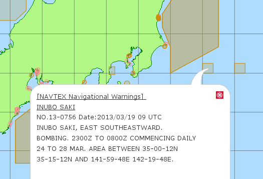
- Notices to Mariners and Navigational Warnings Location Map
Map with the location of Preliminary and Temporary Notices to Mariners, Local, NAVAREA and NAVTEX Navigational Warnings.
- Addition to the List of Aids to Navigation
The vessels be equipped with the "List of Aids to Navigation" based on the law, and also be equipped with the "Addition". The "Addition Vol.1" is published twice a month (on the 2nd and 4th Fridays every month). The "Addition Vol.2" is published every month (on the 4th Friday).
- Yチャート・Sガイド発行後の変更情報
Yチャート・Sガイドでは、次回の改訂まで記載内容の訂正を行いませんので、発行後に入手した変更情報は当ページで提供しています。
- Annual Edition of Notices to Mariners 2022
List of Contents: Information about maritime safety information, Notices to mariners, Navigational warnings (Japan), Miscellaneous information.
- Notices to Mariners
Printed copies of the Notices to Mariners and chartlets(blocks)on the JHOD Website may be used as an equivalent to the paper version of the Notices to Mariners and chartlets (blocks). It should be noted that the chartlets (blocks) printed from the website, may not have the same quality and accuracy as the paper version, depending on the quality and condition of the printer and ink used. The Japan Coast Guard (JCG) does not accept any responsibility whatsoever for the accuracy and/or reliability of the information as displayed or printed by the user's equipment.

- List of Charts and Publications (JHA)
Japan Meteorological Agency (JMA) / 気象庁
- Marine Meteorological Information Services for Shipping and Fishing
To promote the safe and economical navigation of vessels at sea the Japn Meteorogical Agency (JMA) issues a variety of marine meteorogical information for shipping and fishing. JMA hopes that this brochure will promote understanding of the information issued by JMA and thus contribute to safer and more economical navigation.
- 海上警報・予報
海上警報・海上予報とは。海上警報の種類。海上警報・海上予報の発表海域。
- 潮汐・海面水位のデータ
全国各地における潮位の予測値(天文潮位)を掲載しています。s満潮・干潮 - 毎時潮位(グラフ)- 毎時潮位(表)(Tide for Japan).
- 潮汐・海面水位の知識
潮汐の仕組み、潮汐観測の仕組み、高潮、副振動、異常潮位、波浪効果による潮位上昇、用語集。
- Marine Weather Warnings for Japan
Map with marine weather warnings for Japan: Typhoon (wind speed > 64kn), Storm (>48kn), Gale (>34kn), Near gale (>28kn), Sea swell, Ice accreation, Dense fog (visibility < 0.3NM) and Volcanic marine warning.
Marine Weather Warnings for Japan: Typhoon - Storm - Gale - Near Gale Marine Weather Warnings for Japan: Typhoon - Storm - - Gale - Near Gale - Online Marine Radiofax Charts / 船舶向け天気図
Page in Japanese. Graphical information, including surface weather maps and ocean wave charts, is broadcast through JMH by radiofacsimile for the western North Pacific. In the winter season, sea ice forecasts and bulletins are also issued for the Sea of Okhotsk. Analysis and prognosis charts for the western North Pacific on the radio facsimile (JMH station) are placed on this web site.
- 外洋波浪予想図 ・ 沿岸波浪実況図
日本周辺海域の波の高さを1mごとの等高線で表示しています。4m未満の領域では0.5mごとの補助線(破線)も表示しています。波の高さは「有義波高」で示していますが、 実際の個々の波には、有義波高よりも高い波が含まれているので注意が必要です。
- Wave charts around Japan and Western North Pacific
Wave analysis and forecast charts around Japan and for Western North Pacific. Significant Wave Height (SWH) the average height of the highest one-third of waves is shown in the chart. Generally, each wave may happen to be higher than SWH. Also PDF file with color or B&W charts for analysis or forecast.
- Dynamic color map with wave height: Around Japan - Western North Pacific
- Static color charts with wave height around Japan or for Western North Pacific (HTML/PNG file, 00Z or 12Z)
- Static B&W charts with wave height analysis for 00Z : Around Japan - Western North Pacific (HTML/PNG file, also 12Z)
- Static B&W charts with wave height forecast for 00Z : Around Japan - Western North Pacific (HTML/PNG file, also 12Z)
- Guide to the Wave Chart
Sea wave forecast charts for the Western North Pacific. Height in metres
- Sea ice Condition Chart
Black and white sea ice concentration chart with bulletin for the North-East Asian marginal seas (sea of Okhotsk) every tuesday and friday during the freezing season.
- Sea of Okhotsk, B&W Sea ice condition chart: PNG chart - PDF chart
- North-East Asian marginal seas: Latest sea ice condition chart - Daily ice condition chart
- Hokkaidō island: Sea ice condition chart (JCG)
- Hokkaidō island: Ice information (JCG)
- Hokkaidō island: B&W forecast chart
- Guide to Sea Ice Information
- 海氷の知識
海氷、気候変動と海氷、海氷の影響(北海道)、海氷用語の説明、海氷の種類。海氷解析に利用したデータについて、オホーツク海周辺図。
- 海氷に関する診断表、予報、データ
s
このページには、北海道沿岸の流氷やオホーツク海・北極・南極の海氷の変動に関する情報などを掲載しています。なお、掲載している情報は海氷シーズンにのみ更新されるものがあります。
- オホーツク海、海氷解析図
- 全般海氷情報
- 数値海氷予想図
- オホーツク海の海氷解析図
- 北海道地方海氷情報: 短期 - 長期
- 北海道の海、最新の海氷速報 (海上保安庁)
- 長期海氷情報(オホーツク海の海氷の今後1か月の見通し)
- Tropical Cyclone Information
Chart around Japan and Western North Pacific with tropical cyclone of tropical storm (TS) intensity or higher.
- 台風について
台風は、毎年のようにわが国に襲来し、きわめて大きな災害をもたらすことがあります。それらの情報を有効に利用し、災害を防止・軽減するためには台風に関する正しい知識が不可欠です。
- JMA's Bulletin: The Ship and Maritime Meteorology
This bulletin aims to promote useful marine weather observations/reports from ships and familiarize readers with weather and marine information provided by JMA. The publication mainly covers topics of interest to mariners, marine weather observations, recent announcements about JMA’s marine weather services, and more. All articles appear both in English and in Japanese. The bulletin is issued twice a year.
- Ships' Weather Observations/Reports: Reference
Marine meteorological observation is indispensable to provide weather information for ships such as marine meteorological forecast or warnings, and is also used for monitoring and study of climate change such as global warming. It is highly appreciated that ships will cooperate on marine meteorological observations and reports as Voluntary Observing Ships (VOSs). The website "Ships' Weather Observations/Reports" is to provide information to support VOS activities.
- Marine Meteorological Observations and Port Meteorological Services
- Guide to Weather Observations for Ships - Guide to Ships' Weather Reports
- Images of typical clouds - Beaufort scale of wind force
- Marine Meteorological Information Services for Shipping and Fishing

| | K |


L'urgence prime la forme - By Cr - 2012-2024
For updates, corrections, new charts or new documents please send an e-mail to
For my father and my mother / Pour mon père et ma mère


