~ |
Online free nautical charts and publications
open data/open access - libre accès
Cartes marines gratuites et ouvrages nautiques en ligne
 | R |

| T | 
| ||
S
Singapore/Singapour
Slovenia /Slovénie
South African/Afrique du Sud
About Nautical Free
Nautical Free provides a list of free nautical charts and online publications.There is a list by country from letter A to letter V, for each country the organizations and for each organization a list of free online documents (charts, nautical books, notice to mariners...). There is two special lists: one for the international organizations and one for the private companies. There is also a reverse list by type of documents: sailing directions, radio signals, tide tables, nautical charts... You can also find on Nautical Free wave forecast maps for tomorrow, space weather forecast for GPS, how to check your computer clock, as well as information about celestial navigation or about ice navigation...
Au sujet de Nautical Free
Nautical Free fournit une liste de cartes marines gratuites et d'ouvrages nautiques en ligne.Il y a une liste par pays de la lettre A à la lettre V, pour chaque pays les organisations et pour chaque organisation une liste de documents libres en ligne (cartes marines, ouvrages nautiques, avis aux navigateurs...). Il existe deux listes spéciales : une pour les organisations internationales et une pour les sociétés privées. Il existe également une liste inverse par type de documents : instructions nautiques, ouvrages de radiosignaux, tables des marées, cartes marines... Vous trouverez également sur Nautical Free des cartes de prévision de la hauteur des vagues pour demain, des prévisions de la météo de l'espace pour les GPS, comment vérifier l'heure de son ordinateur, ainsi que des informations sur la navigation astronomique ou la navigation dans les glaces...
Advice / Conseils
For navigation use only updated regulatory documents /
Pour la navigation n'utiliser que des documents réglementaires à jour.
GPS is more accurate than nautical charts /
Un GPS est plus précis qu'un carte marine
Web Servers / Serveurs Web
You can use the nearest or faster server / Vous pouvez utiliser le serveur le plus proche ou le plus rapide :
- French mirror with one page by section / Serveur en France avec une page par section : http://nauticalfree.free.fr
- French mirror on one page / Serveur en France sur une page : http://nauticalfree.free.fr/onepage.html
- French mirror without image on one page / Serveur en France sans image sur une page : http://nauticalfree.free.fr/noimage/
- US mirror with one page by section / Serveur au États-Unis avec une page par section : http://nauticalfree.eu5.org
- US mirror on one page / Serveur au États-Unis sur une page : http://nauticalfree.eu5.org/onepage.html
- US mirror without image on one page / Serveur au États-Unis sans image sur une page : http://nauticalfree.eu5.org/noimage/
- US mirror on seven pages / Serveur au États-Unis sur sept pages : https://sites.google.com/site/nauticalfree/
Caption / Légende
- The nautical books are in standard fonts / Les ouvrages sont en caractères droits
- In Italic the maps and the charts / Les cartes sont en italiques
- The last item for an organization is the Notices to Mariners. The first issue of each year is often a special publication /
La dernier item pour un service hydrographique est un lien vers les avis au navigateurs. Le premier numéro de chaque année est souvent un numéro spécial
- Raster Navigational Charts (RNC)
- Bitmap electronic images of paper charts that conform to IHO standard S-61 /
Carte marine matricielle, fac-similé numérique d'une carte papier (scan) conforme à la norme de l'OHI S-61 - Electronic Navigational Charts (ENC)
- Vector charts that conform to IHO standard S-57 /
Carte électronique de navigation, carte vectorielle conforme à la norme de l'OHI S-57
|
|
Cartes marines gratuites et ouvrages nautiques en ligne : Singapour, Slovénie, Afrique du Sud, Espagne et Suède
S
- Singapore / Singapour
- Slovenia / Slovénie
- South Africa / Afrique du Sud
- Spain / Espagne
- Sweden / Suède
Singapore / Singapour
Maritime and Port Authority of Singapore (MPA) - Hydrographic Division
- Index of Charts and Publications (2017)
The Hydrographic Department of the MPA publishes and maintains nautical charts covering the Malacca and Singapore Straits from One Fathom Bank to Horsburgh Lighthouse The MPA and the United Kingdom Hydrographic Office (UKHO) have jointly produced a series of nautical charts called the Dual Badged Charts covering Singapore port waters and its approaches. The Singapore Electronic Navigational Chart (ENC) covers Singapore Port Waters and their approaches. There is also a handy sized atlas of charts covering the Singapore Strait and adjacent waterways, specially designed for small craft and recreational sailors. Index of charts and publications pages 1 to 13.
- List and map of Singaporean nautical charts
- List and map of dual badged charts
- List and map of Singapore ENC
- Symbols Abbreviations Terms and S-57 Objects

This publication contains the Symbols Abbreviations Terms and S-57 Objects used on International as well as national Nautical and Electronic Navigational Charts of the Hydrographic Department, Maritime and Port Authority of Singapore. These are based on the Chart Specifications and S-57 Specifications of the International Hydrographic Organization (IHO).
- STRAITREP - Vessel Traffic Information System
With the Singapore Strait and Singapore port waters as some of the busiest in the world, an advanced VTS (Vessel Traffic Service) is essential for the safe and efficient navigation of ships in these waters. STRAITREP is the Mandatory Ship Reporting System in the Straits of Malacca and Singapore. Ships in these waters report under STRAITREP to Singapore’s Vessel Traffic Information System (VTIS), operated by MPA. The IMO has adopted STRAITREP that was proposed by Indonesia, Malaysia and Singapore.
- Maps of the STRAITREP operational areas: Strait of Malacca, zoom on Singapore and VHF channels
- Safe Passage - The Straits of Malacca and Singapore
This pamphlet has been prepared to give you a quick guide to ensure a safe passage for ships in the Straits of Malacca and Singapore (SOMS). The purpose is to help you to navigate along the 435 mile long busy and narrow waterway in a safe manner by drawing attention to several measures and local conditions that mariners should be aware of (West of England).
- VHF Communication for Singapore
Notifications, declarations and VHF channels for vessels arriving in Singapore. The VHF communication channels listed are for: MPA and other agencies - Safety and emergencies - Immigration/port health clearance - Pilotage, tug and waterboat services - Oil terminals.
- VHF reporting procedures in the TIA of East Johor Strait
VHF radio telephone reporting procedures for vessel manoeuvring within the Traffic Information Area (TIA) in the East Johor Strait. With chartlets of the strait and the TIA.
- Digital Tidal Atlas
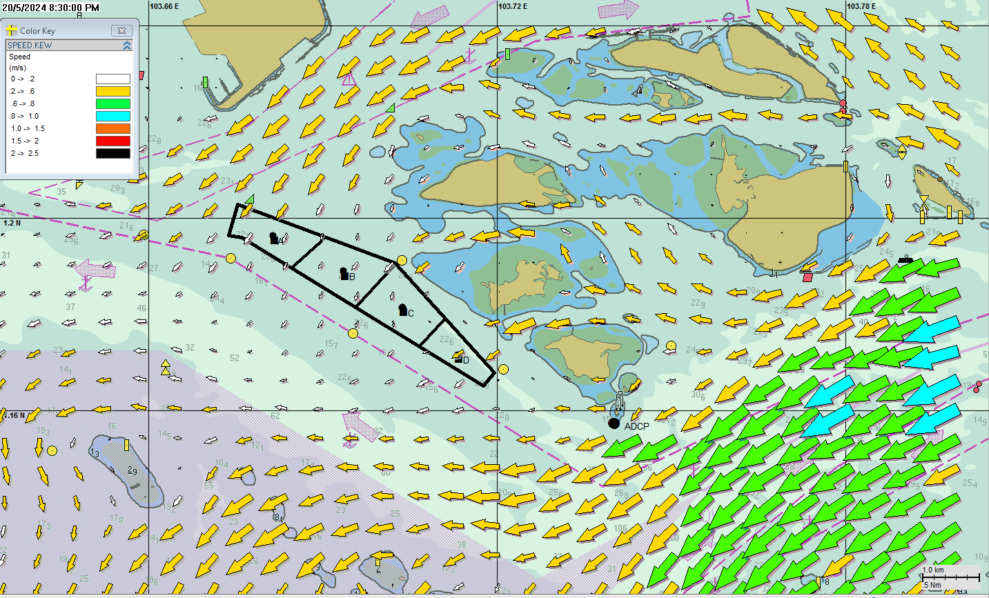
The tidal current information for the selected area is a simulated current only. The model bathymetry is generated based on the seabed information in navigational charts and sounding data. Cover Sudong anchorage and Eastern Bunkering anchorage. The atlas provides data with an Excel file for time series or displays an image with tidal currents. The current forecast exists for 7 days per half hour. Speed in metre per second (m/s), for knot multiply by 2. All links given are in Singapore Time (GMT+0800 hours).
Singapore, Sudong Anchorage - Tidal currents forecast in 1 hour (UTC+8) - Pilotage Guidelines
Pilotage guidelines for vessel movements in the port of Singapore. The pilotage guidelines are intended to assist port users when booking pilots and ordering tugs, on the advice of the pilotage service provider, for their vessels.s
- The Anchorages of the port of Singapore
The anchorages of the port of Singapore are divided into 3 sectors: Eastern sector, Western sector and Jurong sector. Each anchorage has its designated purpose.
- Port Marine Notices
Warnings for the port of Singapore.
- Singaporean Notices to Mariners (NTM)
The monthly Notices to Mariners contain corrective information affecting charts published by the Hydrographic Department, Maritime and Port Authority of Singapore. The information contained in these Notices should be updated on the charts affected. Content: Index of Charts & Publications, New Publications, Notices to Mariners and Chart Corrections, Temporary and Preliminary Notices, Navigational Information, Amendments to Publications,Reprint of Radio Navigational Warnings, Extract of Admiralty Notices to Mariners for Dual-Badged Charts.

- Index of Charts and Publications (2017)
Meteorological Service Singapore (MSS)
- Astronomical Data and Tides (MSS)
Astronomical data like: sunrise and sunset, moonrise and moonset, high and low tides. Tidal height is in metres above the ‘Chart Datum’, which is the lowest water level recorded over a fixed period (usually 18 years) at a particular point. Data for today or tomorrow with 24 hour detail, also monthly data.
- Tide Timings (NEA)
The tidal information is obtained from the Maritime and Port Authority (MPA) of Singapore. Tidal height is in metres above the ‘Chart Datum’, which is the lowest water level recorded over a fixed period (usually 18 years) at a particular point. Display the time, height in metres of high or low tides.
- Significant Wave Charts (MSS)
By the Meteorologial Service Singapore (MSS). Combined sea and swell describes the combined height of the sea and the swell that mariners experience on open waters. The height of the Combined sea and swell refers to the average wave height of the highest one third of the waves (measured from trough to crest). Combined sea and swell is also known as total wave height, or significant wave height. Some waves will be higher and some lower than the significant wave height. The height of highest waves can be nearly twice as high as the significant wave height. Available: 24hr, 48hr and 72hr forecasts.
- Tropical cyclone information
Tropical cyclone information for the areas around Singapore: Western Pacific and Indian Oceans.
- Astronomical Data and Tides (MSS)

Slovenia / Slovénie
Slovenian Maritime Administration / Uprava Republike Slovenije za pomorstvo
- Seznam kart in publikacij
Slovenske pomorske karte - Slovenske navtične publikacije.
- Navtični vodnik - Slovenskega morja in obale
Navtični vodnik slovenskega morja in obale je edina uradna publikacija v Sloveniji, ki na enem mestu združuje večino potrebnih in koristnih informacij v zvezi s pomorstvom in navtičnim turizmom. Vodnik podaja informacije o slovenskem morju in obali, ki se nanašajo na geografske, oceanografske in meteorološke podatke. Zbrani in povzeti so pomembnejši predpisi in drugi upravni akti, ki urejajo področje pomorstva in navtičnega turizma v Sloveniji. Predstavljene so osnove navigacije ter znanj in veščin, potrebnih za prijetno in predvsem varno plovbo (GIS).
HTML Nautical guide for Slovenia in Slovenian: COLREGS - Ports and anchorages...

- Notice to Mariners / Obvestila za pomorščake
Slovenska Obvestila za pomorščake so namenjena objavljanju informacij, ki so povezane z varnostjo plovbe. Publikacija izhaja mesečno v izdaji ministrstva pristojnega za pomorstvo, v njej pa so zbrani popravki in spremembe slovenskih pomorskih kart in publikacij ter opozorila morebitnih del na morju ali obali in morebitno nedelovanje objektov, ki lahko vplivajo na varnost plovbe.
Monthly notice to mariners. Contents: Explanatory Notes, Corrections of Charts, Corrections of Publications, Information (Catalogue of Slovenian Charts and Publications).
- Seznam kart in publikacij

South Africa / Afrique du Sud
South African Navy Hydrographic Office (SANHO)
- Catalogue and Indexes of SAN Charts and other Hydrographic Publications (SAN HO-3)
Contents of the catalogue : Price List of Charts, Diagrams and Publications - Index of Navigational Charts, Electronic Navigational Charts, Publications, Diagrams and Miscellaneous - General Information -Agents for the Sale of South African Charts and Hydrographic Publications - Distributors of Electronic Navigational Charts - Limits of Indexes. There is an abridged version of the Catalogue and Indexes of SAN Charts and other Hydrographic Publications.
- Paper Charts
- ENC Products: General - Coastal - Approaches - Harbours
- Navigational Publications
- South African Tide Tables
This page allows you to select the current month's tidal information for any of the tidal ports listed. Please select a port from the drop-down list provided on the map.
- Summary of Navigational Message Currently in Force
Show the numbers and title of NAVAREA VII and Coastal Navigational Warnings Bulletins in force. This information is only updated during working hours 0730-1600 Mon - Fri. The availability of Navigational Warnings on the web does not relieve Masters / Captains of the requirement to receive Navigational Warnings via IMO/IHO approved broadcast systems, as websites are not continuously updated and not necessarily monitored for correctness.
- Coastal Navigational Warnings
For waters out to about 150 miles around the Republic of South Africa and Namibia, Coastal Navigational Warnings of an urgent and temporary nature are broadcast simultaneously on all frequencies from Coast Radio Stations and via Navtex. This information is only updated during working hours 0730 -1600 Mon - Fri.
- NAVAREA VII Messages
Long-range warnings are broad cast in the NAVAREA VII service. This information is only updated during working hours 0730-1600 Mon-Fri.
- Annual Summary of Notices to Mariners 2021
To supplement Monthly NMs, the SANHO produces an Annual Summary of Notices to Mariners containing the Annual Statutory Notices to Mariners. This publication is published annually in January each year. Contents: Agents for the Sale of Charts, Immediate Navigational Warnings, Storm Warnings to Shipping, The SAFREP and AMVER Systems, Instructions to Ship Radio Stations, Safety of Navigation, Weather Reports from Ships, South African Search and Rescue Organisation (SASAR), Vessel Traf fic Service (VTS), Differential Global Positioning System (DGPS), Meteorological and Oceanographic Data Buoys, South African Maritime Safety Authority (SAMSA) Reporting System...
- Cumulative List of South African Notices to Mariners 2021
To assist users in identifying outstanding Notices to Mariners and audit trails for a particular chart or charts, the SANHO produces a publication entitled the Cumulative List of South African Notices to Mariners, published on a monthly basis. This publication lists all charts currently available together with a complete cumulative list of all NM numbers affecting each chart.
- Notices to Mariners
South African navigational charts and publications can be maintained up to date for safety critical and important navigational information through the South African Notices to Mariners (NMs) service. The Notices to Mariners publication is a complete compilation of all South African chart and publication updates issued in any one month. It is divided into six sections: Section I - Explanatory Notes and Index, Section II - SAN Notices to Mariners. Updates to Standard Navigational Charts, Section III - South African Charts and HO Publications - New Charts/Editions, Section IV - Corrections to SAN HO Publications, Section V - Corrections to SA List of Lights and Radio Services, Section VI - Reprints of Radio Navigational Warnings.
- Catalogue and Indexes of SAN Charts and other Hydrographic Publications (SAN HO-3)

Spain / Espagne
- Instituto Hidrográfico de la Marina (IHM)
- Salvamento Marítimo (SASEMAR)
- Agencia Estatal de Meteorología (AEMET)
Instituto Hidrográfico de la Marina (IHM)
- Catálogo Web de Cartas Náuticas
Catálogo Web de Cartas Náuticas: Cartas de Papel - Cartas Electrónicas - Cartas Deportivas - Buscador de Cartas Náuticas - Ayuda Catálogo de Cartas (HTML).
- Catálogo Web de Publicaciones Náuticas
Catálogo Web de Publicaciones Náuticas: Libros de faros - Radioseñales Náuticas - Anuario de Mareas - Publicación INT 1... (HTML).
- IDE-IHM - Geoportal de la Infraestructura de datos espaciales del IHM
View online charts (ENC) / Cartes marines consultables en ligne (CEN)
Not for navigational use / Ne pas utilisez pour la navigation
Con este Geoportal IDE-IHM, se ofrecen una serie de servicios de información geográfica náutica que, indudablemente, satisfarán muchas de las demandas recibidas hasta la fecha, ahora, de forma prácticamente automática. Por parte del IHM, se declina cualquier tipo de responsabilidad en el uso, para fines náuticos, de la información aquí proporcionada.

Atlantic, North Coast of Spain, Santander Bay, 1: 22,000 (IHM)- Las Cartas Electronicas de Navegacion y las Prescripciones de Transporte: Hechos
Las respuestas de todos los sectores relacionados con el uso de cartas y de equipos de presentación de cartas electrónicas muestran la necesidad de proporcionar información sobre la situación y las normas que se aplican a los productos y equipos ya disponibles en el mercado. Se ha creado este documento para ayudar a aclarar algunas de las dudas existentes.
- Lights and Fog Signals
Peninsula, Balearic and Canary Islands. This application is available in two formats: Static version, data in tables and Interactive. This tool allows for the access of all interested users to data on maritime signals published in the spanish list of lights Faros y Señales de Niebla, Parte I y II. This tool does not replace in any way the aforementioned publications, and consequently mariners still must carry properly updated nautical publications on board.
- Faros y Señales de Niebla
Península, Baleares y Canarias. El Libro de Faros y Señales de Niebla se presenta en los siguientes formatos: Versión accesible Navegador con Javascript deshabilitado - Versión gráfica e interactiva. Esta aplicación facilita, a todos los usuarios interesados, el acceso a los datos sobre señalización marítima existentes en las publicaciones "Faros y Señales Marítimas, Partes I y II". De ningún modo, esta aplicación sustituye a las publicaciones anteriormente citadas, y por lo tanto los navegantes no están exentos de continuar llevándolas a bordo, así como el resto de las publicaciones náuticas, debidamente actualizadas (HTML).
- Distancias entre puertos
Distancias entre puertos. Selecione un Puerto de Origen y un Puerto de Destino en el menú desplegable (HTML).
- Correcciones a los Derroteros
Las correcciones se facilitan en un único archivo pdf por cada derrotero, en el que constan todas las correcciones que afectan al mismo desde su última edición, o la del último suplemento, si lo hubiere.
- Mar Digital - Biblioteca Marítima Digital de la Armada
Biblioteca marítima digital: Hidrografía, Oceanografía, Ingeniería Electrónica y de Comunicaciones, Navegación...
- Cartografía Náutica - La Carta Electrónica
- Astronomía, Meteorología y Oceanografía - Curso de Meteorología y Oceanografía
- Introducción a la Navegación Costera - Sistemas Electrónicos de Navegación
- Diccionario marítimo de la A a la Z
- ...
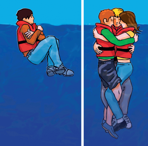
Supervivencia en el mar - Hipotermia - Cartas de Seguridad de corredor recomendado (MRTC)
Cartas de seguridad marítima disponibles: 1) SEG100 - Carta de seguridad marítima para el mar Rojo, golfo de Adén y mar de Arabia. Recomendaciones para prevenir la piratería y actuar en caso de ataque en el golfo de Aden y/o en las aguas frente a la costa de Somalia. Recomendaciones adicionales dirigidas a busques dedicados a la pesca. Escala 1: 7 500 000. 2) SEG200 - Carta de seguridad marítima para el Golfo de Guinea. Zona de mayor concentratión de incidentes de piratería y delincuencia armada. Escala 1: 5 500 000. Cartas no válidas para la navegación.
- Radiocomunicaciones (Ministerio de Transportes, Movilidad y Agenda Urbana)
- Estaciones costeras VHF, MF y HF del servicio móvil marítimo para la seguridad
- Horarios y frecuencias VHF, MF y NAVTEX de los boletines metereológicos
- Horarios y frecuencias NAVTEX de los boletines metereológicos
- Horarios y frecuencias NAVTEX de los avisos a navegantes y boletines meteorológicos
- Tablas informativas sobre comunicaciones marítimas
- Cuadro de procedimientos de operación para situaciones de socorro
- Radioavisos NAVAREA III
Radioavisos NAVAREA III en vigor. La disponibilidad de los radioavisos NAVAREA III en la página Web del IHM no exime a los Capitanes de los buques de la obligación de recibir dichos radioavisos a través del sistema Internacional SafetyNET (Inmarsat).
- NAVAREA III warnings
NAVAREA III warnings in force. The availability of NAVAREA III warnings on the IHM Web site does not exempt Masters/Captains to receive NAVAREA III warnings via the International SafetyNET system (Inmarsat)
- Grupo Especial Anual 2021
Contenido: avisos generales (mantenimiento de las cartas, reglas sobre el uso de cartas a bordo, fiabilidad y uso de las cartas...) y avisos temporales y preliminares.
- Avisos a los Navegantes
Para facilitar el acceso y difusión del Grupo Semanal de Avisos a los Navegantes, éste se pone a disposición en la página correspondiente al IHM en la Intranet Armada y en Internet

- Catálogo Web de Cartas Náuticas
Salvamento Marítimo (SASEMAR)
- Consejos Prácticos de Seguridad en actividades náuticas
Leer con detenimiento esta publicación ayuda a actuar en situaciones comprometidas y saber cómo disminuir los riesgos. Contiene información imprescindible para pedir ayuda, saber cómo actuar al recibirla y cómo prestar auxilio a otros navegantes en apuros. Índice : Centros de coordinación de salvamento - Salvamento Marítimo - Seguridad en embarcaciones de recreo - Antes de zarpar - Información meteorológica - Durante la navegación - Prevenir los abordajes - Qué hacer en caso de emergencia - Uso de la radio en emergencias - Hipotermia - Seguridad en actividades náuticas.
- Dispositivos de separación de tráfico (DST)
El establecimiento de los dispositivos de separación de tráfico ha reducido considerablemente el riesgo y el número de accidentes por colisiones y varadas en el tráfico marítimo. En España existen varios dispositivos de separación de tráfico: Finisterre, Estrecho de Gibraltar, Cabo de Gata, Canarias Oriental y Canarias Occidental. El DST con mayor Tráfico es Tarifa, seguido por Finisterre y Cabo de Gata.

- Guía Sanitaria a Bordo (ISM)
La Guía Sanitaria a Bordo forma parte obligada del botiquín del barco, editada y distribuida gratuitamente por el ISM , está configurada como un vademécum de los conocimientos básicos que deben tener los responsables sanitarios de los buques y como un catálogo práctico de procedimientos a seguir pero siempre a indicación de los facultativos del Centro Radio-Médico de la Entidad. La idea fundamental que ha dirigido la redacción de esta Guía es la de que sirva de instrumento en las consultas médicas realizadas a distancia. Además, debe permitir poder utilizar el botiquín en caso de necesidad urgente o cuando, por imposibilidad técnica, no se pueda comunicar con el Centro Radio-Médico. Pero, también, la Guía debe servir de recuerdo, en muchos casos primera información, de las medidas preventivas a adoptar en los barcos para mantener la salud y, si llega el caso, saber qué hacer ante un fallecimiento a bordo.
- Equipos de radiocomunicaciones
El "Reglamento por el que se regulan las radiocomunicaciones a bordo de buques civiles españoles" identifica los equipos que deben llevar las embarcaciones de recreo, según las zonas de navegación en las que están autorizados a navegar. Los equipos consisten en estaciones de radio fijas (en VHF y OM, con Llamada Selectiva Digital - LSD), Inmarsat, estaciones portátiles de VHF, terminales NAVTEX, radiobalizas (RLS - EPIRB), respondedores de radar (RESAR - SART), y sistema de posicionamiento por satélite (GPS).
- El tiempo: Boletines meteorológicos marinos VHF, OM Y NAVTEX
Canales y horarios para los boletines meteorológicos marinos: Centros de Salvamento Marítima (VHF), Estaciones Costeras (MF y VHF), Red national de centros NAVTEX.
- Radioavisos
Radioavisos para España / Radio Navigational Warnings for Spain.

- Consejos Prácticos de Seguridad en actividades náuticas
Agencia Estatal de Meteorología (AEMET)
- Guía de Meteorología Marítima
Resumen productos marítimos. Índice: Tipos de boletines - Zonas de responsabilidad española de Alta Mar (Mediterráneo) - Zonas de responsabilidad española de Alta Mar (Atlántico) - Boletines de Alta Mar - Boletines de Aviso para Alta Mar - Boletines de Predicción marítima de Alta Mar - Boletines NAVTEX - Horarios de emisión de los boletines NAVTEX - Difusión de los boletines de Predicción marítima de Alta Mar - Información para zonas costeras - Zonas costeras de responsabilidad española - Boletín Meteorológico y Marino para las zonas costeras - Difusión de la información costera - Información marítima disponible en la web de la Agencia Estatal de Meteorología - Información marítima disponible en la web de la Organización Meteorológica Mundial.
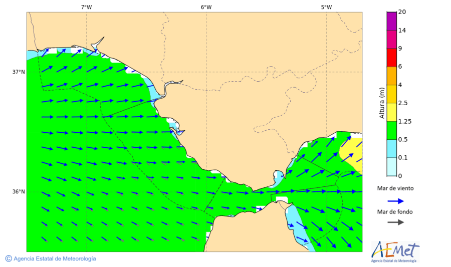
- Predicción Marítima: mapas con altura de oleaje
El color nos indica la altura significativa de la mar total, que es la mar resultante de la combinación de mar de viento y mar de fondo (la altura significativa se define como la media aritmética del tercio de olas más altas), y la escala de colores viene a la derecha. Las flechas se refieren a la mar de viento (flecha gris) y la mar de fondo (flecha blanca). La longitud de dichas flechas es proporcional a la altura relativa de cada componente respecto a la altura de la mar total, con lo que nos da idea de cual de ellas es la que predomina, y el sentido de la flecha nos indica el de propagación del oleaje.
Estrecho de Gibraltar: Mapas de altura de oleaje con mar total para mañana - Altura en metros
- Información divulgativa de AEMET sobre meteorológica marítima
- Escalas de viento y oleaje : escala anemométrica Beaufort, estado de la mar de viento (escala Douglas)
- Glosario de términos : avisos, viento, mar, visibilidad...
- MeteoNav : Servicio Meteorológico para la navegación marítima
Sistema de AEMET para la navegación marítima (MeteoNav) permite obtener predicciones marítimas a lo largo de una trayectoria definida por el usuario, quien decide las fechas y horas de salida y de llegada, el lugar de salida y llegada, y, opcionalmente, los puntos de paso.
- Guía de Meteorología Marítima

Sweden / Suède
- Swedish Maritime Administration (SMA) / Sjöfartsverket
- Swedish Meteorological and Hydrological Institute (SMHI) / Sveriges meteorologiska och hydrologiska institut
Swedish Maritime Administration / Sjöfartsverket
- Sjökortskatalog

Sjöfartsverkets sjökortskatalog över svenska sjökort och publikationer. I denna finns uppgifter och indexkartor över samtliga svenska sjö-och båtsportkort samt övriga produkter.
- Sjökortsymboler (Utdrag ur Kort 1)
Beteckningar i svenska sjökort. Följande symboler, förkortningar och begrepp är ett utdrag från Kort 1 / INT 1.
- Facts about Charts and Carriage requirements
The SOLAS International Convention includes a requirement for all ships to carry to up-to-date nautical charts and publications for the intended voyage. Progressively, the chart carriage requirement for certain classes of vessels is to be satisfied by electronic means using an Electronic Chart Display and Information System (ECDIS). This publication provide guidance on the regulations and the status of equipment that is available in the market today. In particular the differences between the various types of equipment and the differences between the various types of chart data offered to the users are unclear with respect to the regulations in place (IHO publication S-66, edition 2010). Contents: Overview of electronic charting and regulations, Compendium of Flag State ECDIS requirements, Training requirements, Technical details of electronic charts, Appendix: References and glossary, Revised performance standards for electronic chart display (ECDIS).
- Referensnivåer
Alla djupuppgifter och djupkurvor refererar till en bestämd vattenyta, här beskrivs de olika referensytorna som används i våra produkter: RH 2000, Medelvattenyta, Insjöar och kanaler.
- E-navigatörens 10 budord - Om navigering med GPS och elektroniska sjökort
Att navigera med elektroniska sökort och GPS är både lätt och svårt men det finns en del fallgropar som vi ska försöka förklara i den här broschyren.
- Reporting in VTS areas
There are nine designated VTS areas in Sweden: Luleå, Öregrund, Stockholm, Landsort, Mälaren, Bråviken, Göteborg, Marstrand and Lysekil. The exact border limits of the VTS areas are described in the VTS regulations. Here you may read about how reporting should be done in designated VTS areas (Swedish Transport Agency).
- New routeing system in Kattegat
The International Maritime Organization (IMO) has decided to establish a new routeing system in Kattegat and the northern part of The Sound from 1 July 2020. The intention is to reduce the large number of ships in the old Route T by establishing a new recommended route, Route S, along the Swedish coast from Læsø Island to The Sound.
- SOUNDREP : Mandatory ship reporting system in the Sound
In a joint cooperation, Sweden and Denmark has established an IMO approved Mandatory Ship Reporting System in the Sound, named SOUNDREP, with the purpose of improving the safety of navigation and the protection of the marine environment in the Sound area. New shipping routes will be established in Danish and Swedish waters on the 1st of July 2020.
- Våra lotsområden
Befälhavare på fartyg som har en längd av 70 meter eller mer, en bredd av 14 meter eller mer eller ett djupgående av 4,5 meter eller mer är i allmänhet skyldig att anlita lots på svenskt inre vatten. En lotsbeställning ska göras elektroniskt via MSW Reportal senast fem timmar före önskad tidpunkt för lotsningens början och 24 timmar före önskad tidpunkt för öppensjölotsning. Sjöfartsverket har nio lotsområden: Luleå, Gävle, Stockholm, Södertälje, Kalmar, Malmö, Göteborg, Marstrand och Vänern/Kanalen. Med passageplan.
- Pilot Areas
Information on designated pilotage fairways. The information shows the positions of the valid pilotage lines inserted in charts for each designated pilotage fairway. Also shown are the limits for compulsory pilotage in each fairway as well as the respective boarding areas. Pilot Areas: Lulea and Gavle - Stockholm and Sodertalje - Kalmar and Malmo - Goteborg and Marstrand - Vanern (Swedish Transport Agency).
- Find the Port: Necessary information for vessels calling a port li>Deep Sea Pilots: Ice Pilots in the Baltic Sea and through the Sound
- Deep sea pilotage & ice pilotage
- Sjöfartsverkets karttjänster (Nautical chart viewer)
Sjöfartsverket har utvecklat en kartvisare för att tillgängligöra data som vi tillhandahåller. Kartvisaren är byggd för att visa både statisk och liveuppdaterad information. När du klickar på ett objekt i kartvisaren så visas resultatet under sökträffar vid sidan av kartan. Vår karttjänst är inte avsedd att användas för navigering. Tjänsterna i kartvisaren: Båtsportkortsutbredningar -Djupinformationens kvalitet - Felanmälda Sjösäkerhetsanordningar - Försäljare av sjökort - Lotsområden - Se på Sjökort - Sjömätningsplan - Ufs P- och T-notiser - ViVa (Mer information).
Sjöfartsverkets karttjänster - With yacht on Trollhätte canal
Trollhätte Canal is an important transport link for the commercial shipping, but also a prerequisite for the thousands of boaters that each summer take the great opportunity to travel by sea between the Baltic and North Sea. This leaflet is a presentation of the canal and locks. Also map with overview.
- Sjösäkerhet - fritidsbåtar
Varje år färdas minst 1,5 miljoner personer i vuxen ålder i fritidsbåtar runt om i Sverige. Genom kunskap och gott sjövett kan vi minska riskerna att drabbas av olyckor. Då blir vi tryggare och kan njuta ännu mer av vår vistelse på vattnet.
- Ett säkert båtliv
Varje år färdas minst 1,5 miljoner personer i vuxen ålder i fritidsbåtar runt om i Sverige. Genom kunskap och gott sjövett kan vi minska riskerna att drabbas av olyckor. Då blir vi tryggare och kan njuta ännu mer av vår vistelse på vattnet (Transportstyrelsen).
- Nationell sjöfart
Den 1 juni 2017 infördes nya regler för dig som använder ditt fartyg yrkesmässigt. Reglerna innebär bland annat att du som är fartygsägare har ett ansvar för att systematiskt kontrollera och dokumentera att ditt fartyg är säkert och att din verksamhet bedrivs på ett säkert sätt (Transportstyrelsen).
- Swedish Coast Radio - map / Svensk kustradio
Map of MF and VHF coast radio for Sweden.
- Stockholm Radio
Stockholmradio (SDJ) är Sveriges enda civila kustradiostation.
- VHF- Stations: Map for Sweden and neighboring countries
- Kartor och kanalpna - VHF : Sverige & Norden
- Kustväder (VHF)
- Gränsvåg MF
- Navtex map / Navtexkarta
Map of NAVTEX stations in the Baltic Sea area.
- Winter Navigation 2021-2022

Information about Winter Navigation for industry, ship owners, shippers and charterers. Traffic restrictions are imposed to improve the safety and efficiency of winter navigation. Icebreaker assistance will only be given to vessels, which meet the requirements set out in the traffic restrictions. Contents: General Information, Ice-breaking service, Information about Winter Navigation, Navigating in Ice, Ice Classes and Requirements, Ordinance and Regulations for Winter Navigation, Weather- and Ice- Information (More information).
- Vintersjöfart 2021-2022
Allmänt, Isbrytartjänsten, Vintersjöfartsinformation, Navigering i is, Isklasser och krav, Regelverk för vintersjöfart, Väder- och isinformation (Mer information).
- Sjö- och flygräddning - terminologi
Sjö- och flygräddningstjänst. Beteckningar, förkortningar och begrepp.
- Minor - Riskområden
Östersjöns botten har förhållandevis hög koncentration av minor, ammunition och kemiska stridsmedel som härstammar från tiden under och efter världskrigen. Föremålen kan än i dag vara farliga att komma i kontakt med. På denna sida redovisas områden inom svenskt territorialvatten och svensk ekonomisk zon där risken att påträffa minor är förhöjd.
- Mines - Risk areas
There are areas of the Baltic Sea that still has a high number of old mines, ammunition and chemical weapons originating from the two world wars. These objects might still be dangerous if you encounter them. Areas with enhanced risk of mines within Swedish territorial waters and the Swedish economic zone are shown on this page.
- Navigational warnings
Current Swedish navigation warnings in force, as well as NAVTEX warnings for the Baltic Sea area.
- Allmänna upplysningar (Ufs A)
Liten uppslagsbok för sjöfarande: Sjöfartsverket, Transportstyrelsen, Sjökort och publikationer, Sjötrafikinformation, Föreskrifter, Sjötrafik och sjövägar, Lotsning, Navigeringshjälpmedel, Sjöräddning (SAR) och Maritime Assistance Service (MAS), GMDSS, Maritim säkerhetsinformation (MSI), Meteorologi och oceanografi, Kustbevakning och Sjöpolis, Försvarsmakten informerar, Öppningstider för broar och kanaler.
- Notices to Mariners: General information (Ufs A)
Ufs A - General information for all mariners: Swedish Maritime Administration, Swedish Transport Agency, Charts and Publicationsy, Maritime Traffic Information, Regulations, Fairways, Piloting, Aids to navigation, Rescue at sea, Ship´s equipment, Maritime Safety Information (MSI), Weather, oceanography and sea ice, Coast Guard and Police, Information by the Swedish Armed Forces, Bridges and canals opening times.
- Underrättelser för sjöfarande (Ufs)
Dessa sidor innehåller information för yrkes- och fritidssjöfarten t.ex. notiser med sjökortsrättelser, notiser med temporär och preliminär information samt övrig information som kan vara relevant för den sjöfarande. Notiser kan antingen sökas direkt i Sjöfartsverkets Ufs-databas (uppdateras dagligen) eller läsas i de PDF-filer som publiceras varje vecka. Ufs-häftet utkommer veckovis och innehåller sjökortsrättelser och annan information av vikt för sjöfart i svenska farvatten.
- Ufs-häftet
- Ufs Gällande sjökortseditioner - rättelser
- Gällande P- och T-notiser
- Sök notiser i databasen
- NtM - Notices to Mariners
This webpage contains relevant information to both merchant shipping and pleasure craft, i.e. Notices to Mariners and chart updates. Notices to Mariners are found in the NtM database or as PDF-files. The NtM booklet (Ufs) is published once a week and contains information essential for safe navigation in Swedish waters.

- Sjökortskatalog
Swedish Meteorological and Hydrological Institute (SMHI) / Sveriges meteorologiska och hydrologiska institut
- Tidvatten
Tidvatten är ett fenomen som upprepar sig med stor regelbundenhet. Det uppstår på grund av solens och framförallt månens dragningskraft på jorden. Höjden på tidvattnet runt Sverige är liten, några decimeter längs Västkusten och enbart ett fåtal centimeter i Östersjön (SMHI).
- Vattenstånd och vågor
Kartan visar positioner där det mäts havsvattenstånd eller vågor. Klicka på en punkt i kartan eller använd drop down-listan för att se observationer och prognoser i ett diagram eller tabell (SHMI).
- Nytt referenssystem för vattenstånd i havet
Från och med den 3 juni 2019 uttrycks havsvattenstånd i SMHIs observationer, prognoser och varningar i Rikets Höjdsystem 2000 (RH 2000) istället för relativt medelvattenståndet (RW). RH 2000 är Sveriges nationella referenssystem för höjder och djup. Övergången till RH 2000 är ett steg mot enhetliga referenssystem på nationell nivå och innebär många fördelar. Till exempel underlättar det vid analyser som omfattar både land och hav eller då man vill räkna ut vattendjupet under kölen på en båt eller ett fartyg (SHMI).
- Swedish ice service
The ice service at Swedish Meteorological and Hydrological Institute (SMHI) is responsible for providing up-to-date information about the ice conditions in the Baltic Sea region: Daily ice chart, sea surface temperature chart, ice report.
- Baltic Sea Ice Code
Baltic Sea Ice Code is a four digit code used to describe ice conditions in ports, fairways, coastal areas and certain ship routes. The code is developed in cooperation between the countries around the Baltic Sea to provide a common terminology.
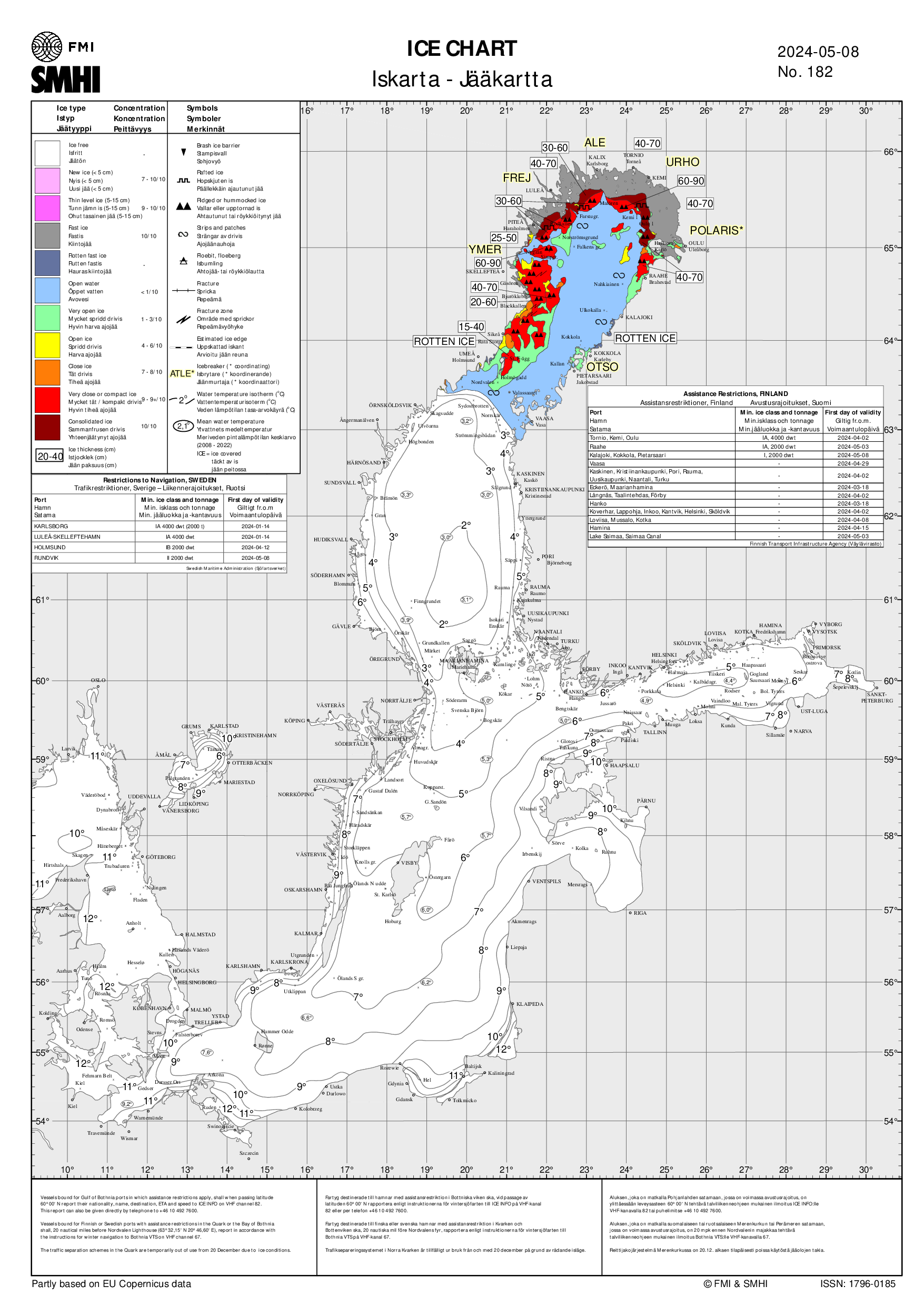
Extract: Ice condition for the Gulf of Finland & Sea Surface Temperature (SMHI)Extract: Ice condition for the Gulf of Finland & Sea Surface Temperature (SMHI) - Istjänsten på SMHI
Istjänsten på SMHI ansvarar för att tillhandahålla nulägesinformation om havsisen i svenska farvatten. På istjänsten jobbar både oceanografer och meteorologer som specialiserat sig på havsis (SMHI).
- Is till havs
Iskartan visar is på havet, Vänern och Mälaren. Isen analyseras av en isexpert utifrån observationer och satellitbilder. Satellitbilderna visar is och ytvattentemperatur till havs. Kartan är en generell analys och isen kan se helt annorlunda ut lokalt. Gör alltid en egen bedömning av isen där du befinner dig. (SMHI).
- Olika typer av is till havs
Det förekommer en mängd olika uttryck för olika slags is. Dessa har med åren förändrats och anpassats till den internationella isnomenklatur för all slags havsis som WMO kommit överens om (SMHI).
- Östersjökoden för havsis
Östersjökoden används för att kortfattat kunna beskriva isförhållandena i farleder, hamnområden och för sjöfarten viktiga passager. Uppdatering av gällande iskoder sker dagligen under issäsongen (SMHI).
- Tidvatten
| | T |


L'urgence prime la forme - By Cr - 2012-2024
For updates, corrections, new charts or new documents please send an e-mail to
For my father and my mother / Pour mon père et ma mère
